

Definitive South Dakota and Nebraska Road Trip Guide: Black Hills, Badlands, and Sandhills
If you love underrated road trips, this one is for you. We are driving through South Dakota's pine-covered Black Hills, into the surreal, eroded geological formations of the Badlands, and down into the Nebraska high plains to experience the treeless, rolling, grass-stabilized landscape of the largest sand dune formation in the Western Hemisphere. It is breathtaking, untamed, and right inside the American heartland.
Whether you are actively planning a road trip or simply dreaming of one, this blog will take you on a journey through the open roads of South Dakota and Nebraska.
Join my family and me as we explore must-see attractions, hidden gems, and the rich history and local character of this remarkable stretch of the Great Plains of the Midwest.
Along the way, I will go beyond the scenery to share the stories, history, and people behind these places, because that is what makes a road trip truly unforgettable.
This guide also highlights lessons learned and extra sightseeing options to help you plan your own adventure.
As a family rooted in the busy rhythms of city life in Ohio, we find that heading out West always brings a deep sense of peace and grounding, and I hope this blog gives you a taste of that same feeling.
This guide details our 14-day journey, highlighting scenic stops, family-friendly experiences, and ideas on where to spend your time.
Our trip ran from the evening of July 25 through the morning of August 9, though a few stops along the way were revisits from previous fall and winter trips.
If crowds are a concern, traveling during the shoulder season in the Black Hills is worth considering. Quieter roads and fewer visitors make for a more relaxed experience, though be aware that several roads typically close starting in mid-December.
My channel’s most successful YouTube video so far is my South Dakota Road Trip Plan from four years ago. My original South Dakota and Nebraska videos and blogs are on TravelGuidesfromKris.com under the “Great Plains” tab. These blogs go into greater detail on many of the destinations covered in this guide.
I planned this family road trip itinerary in Excel, and this is the same timeline we followed along the way. We didn't make it to every place listed; some destinations swapped days, and you'll notice that I've included some scattered notes in my spreadsheet. I'll walk you through the plan as we go and include other notable attractions to consider for your own trip.
To me, the highlights of this trip are driving the scenic highways around Custer State Park, watching the sunrise and sunset over the Badlands, and taking a long drive through the wide, rolling hills of the Nebraska Sandhills.
Our eventful road trip kicked off at the Missouri River Confluence, where western Iowa, northeast Nebraska, and southeast South Dakota meet, and then carried us deep into the historically rich region of South Dakota.
Along the way, we stopped at the unique Corn Palace and the powerful Dignity of Earth and Sky sculpture, then visited the classic Wall Drug for a quick meal and browsing before settling into a peaceful boondocking spot near the Badlands. Heading west, we caught the vibrant pre-rally energy in Sturgis and explored the historic streets of Deadwood. We then spent four nights in Custer State Park, taking time to truly absorb the landscape, hiking to Roughlock Falls, driving the dramatic Needles Highway, fishing, and visiting Mount Rushmore, Wind Cave, and Jewel Cave.
Beyond the Black Hills, we explored the stark beauty of the Badlands in both South Dakota and Nebraska. After visiting Badlands National Park and the Mammoth Site in Hot Springs, we continued to see the unusual formations of Toadstool Geological Park and the historic grounds of nearby Fort Robinson before driving further into the heart of Nebraska. A quick stop at Alliance brought us to Carhenge, a modern Stonehenge-like art installation made entirely of cars. From there, much of the day was spent crossing the vast, sparsely populated Sandhills before wrapping up the journey with a memorable visit to the Omaha Zoo.
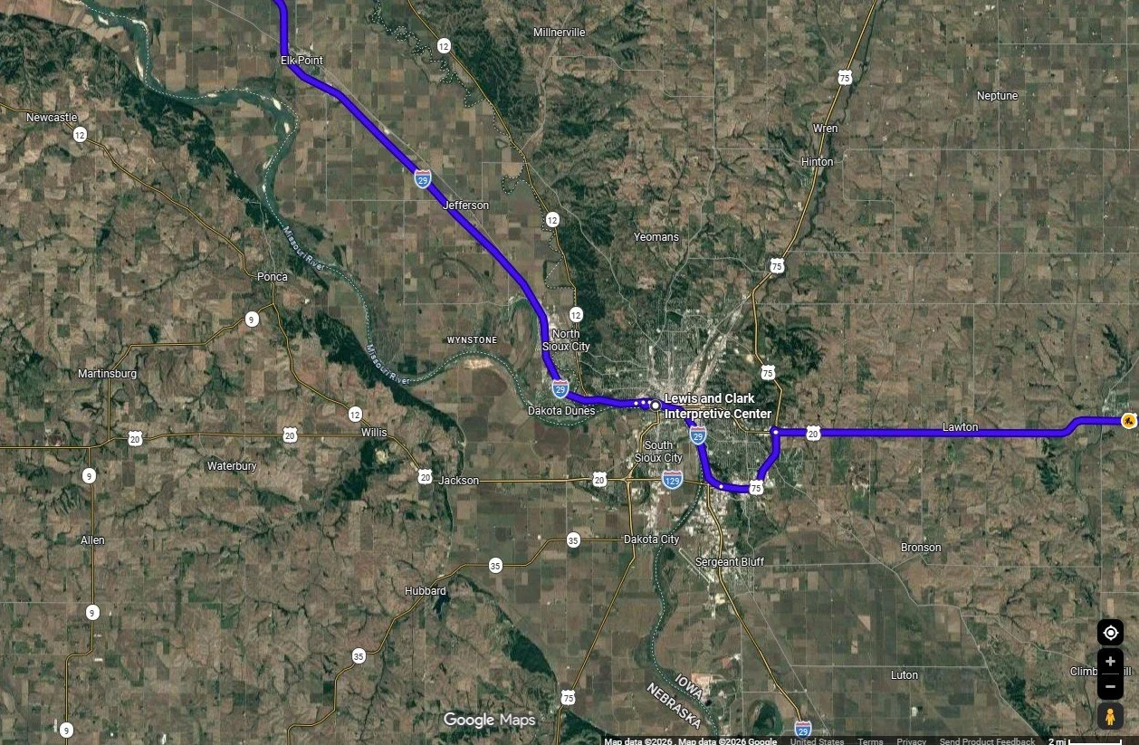
First stop on the road trip, mapped in Google Maps
Sioux City
My family's Road Trip began in Sioux City, at the three-state corner of Iowa, South Dakota, and Nebraska.
Our first destination was the Lewis and Clark Interpretive Center, which offers a valuable opportunity to learn about the expedition's journey and its interactions with Native American tribes. This informative, quick-but-well-done museum is located on a scenic bluff overlooking the Missouri River and an adjacent marina.
Outside the Center, visitors can view engaging sculptures by Wyoming artist Mike Flanagan, including several life-sized bronze animals installed on the grounds of the Interpretive Center and the adjacent Betty Strong Encounter Center, which explores the cultural encounters between Native Americans and European Americans along the river. The 14-foot bronze Spirit of Discovery statue, created by Colorado artist Pat Kennedy and installed in 2002, depicts Meriwether Lewis and William Clark with their Newfoundland dog, Seaman. Note that the Lewis and Clark Interpretive Center is closed on Mondays.
Next door, the Sergeant Floyd River Museum & Welcome Center operates out of a dry-docked 1932 towboat. It spans three levels, featuring exhibits on Missouri River history, Lewis and Clark expedition artifacts, and a large collection of steamboat models. Visitors can explore a pilot house and local history displays throughout the vessel. The Welcome Center also serves as a tri-state Iowa Welcome Center and is open daily, making it a useful stop for travelers seeking information on Nebraska and South Dakota.
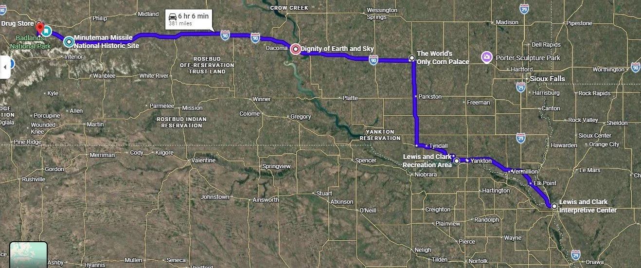
First leg of the road trip, mapped in Google Maps
Lewis and Clark Recreation State Park
Next was our overnight location. For us, a stop at the Lewis and Clark Recreation State Park was dependent on when we departed for our road trip and how long it took to reach South Dakota from Ohio.
I called the morning of our stop to secure the campsite. We didn’t take advantage of the park and lake, but I hope to make it back to go boating, hiking, and for my family to fish.
The Lewis and Clark Recreation State Park sits on the 25-mile-long, man-made reservoir on the Missouri River known as Lewis and Clark Lake. Gavins Point Dam created the lake to manage flooding, aid navigation, and generate hydropower.
While we were at the State Park, we bought an annual state park entrance license for $60; instead of paying $10 per day, we were in a South Dakota State Park during our trip.
Our next campsite was in the Badlands. We made four stops along the way.
World's Only Corn Palace
The first was the World's Only Corn Palace, opened in 1892, where interesting, massive corn art is displayed along the building's façade and around the top of the gymnasium. The exterior corn murals are replaced annually and made from over 275,000 ears of corn, grains, and grasses. The interior of the building showcases pictures of designs from previous years. During the peak tourist season, the gymnasium floor has a large gift shop.
Dignity of Earth and Sky and the Lewis and Clark Welcome Center
Our second stop brought us to the blufftop site overlooking the Missouri River, home to the Dignity of Earth and Sky and the Lewis and Clark Welcome Center. The striking 50-foot stainless-steel statue honors the strength and resilience of the Lakota and Dakota people and glows beautifully when illuminated at night. The sculpture depicts a Native American woman in Plains-style dress with her arms outstretched, holding a star quilt. This textile tradition is deeply rooted in Lakota and Dakota culture. There, star quilts are given as gifts to mark significant life events, serving as symbols of honor and blessing. Dignity of Earth and Sky is a powerful and memorable sculpture created by Dale Claude Lamphere and funded by a Rapid City couple in 2014. The accompanying Lewis and Clark welcome center includes exhibits tracing the Lewis and Clark Expedition’s journey, and there is no shortage of travel brochures to grab for this trip or the next.
1880 Town
About 80 minutes along Interstate 90, you’ll notice the roadside attraction called the 1880 town. The town has over thirty authentic buildings from 1880 to 1920, among other things, to explore.
Minuteman Missile National Historic Site
Along the drive, we made a quick stop at the Minuteman Missile National Historic Site, right off Interstate 90. We arrived when the rangers were locking the gate since it had just closed at 4 pm. Unfortunately, with no information boards or exhibits outside, there wasn’t much to do but peek through the fence and imagine what we missed. The site is designed to educate visitors about the Cold War, the nuclear arms race, and the role of nuclear deterrence that defined an era.
Wall Drug Store
Our next stop, the Wall Drug store, was more fun than I had expected. Spread across multiple buildings, it offers everything from Western-themed apparel to books, plus a cafeteria-style restaurant. The highlight for my girls, though, was the abundance of amusing photo opportunities. Ready to escape the crowded energy of Wall Drug, we headed out in search of the quiet solitude of our campsite for the night.
Badlands Boondock Campspot
One of my favorite evenings of the trip was spent at the Badlands Boondock Campspot, also known as the Nomad View dispersed camping area, located in the Buffalo Gap National Grassland just outside the northern boundary of Badlands National Park near Wall. We arrived late, so there weren’t many sites left to choose from, but we still secured an incredible view of the Badlands wall. After capping off the day with a peaceful sunset and stargazing under the vast night sky, we woke to watch the morning light illuminate the jagged terrain.
We didn’t stay long since the National Park was planned for later in the trip. I chose to visit destinations closer to Sturgis before the motorcycle rally started four days later. After admiring a gorgeous sunrise over the Badlands, we broke camp early to cover some ground, officially kicking off the Black Hills portion of our trip.
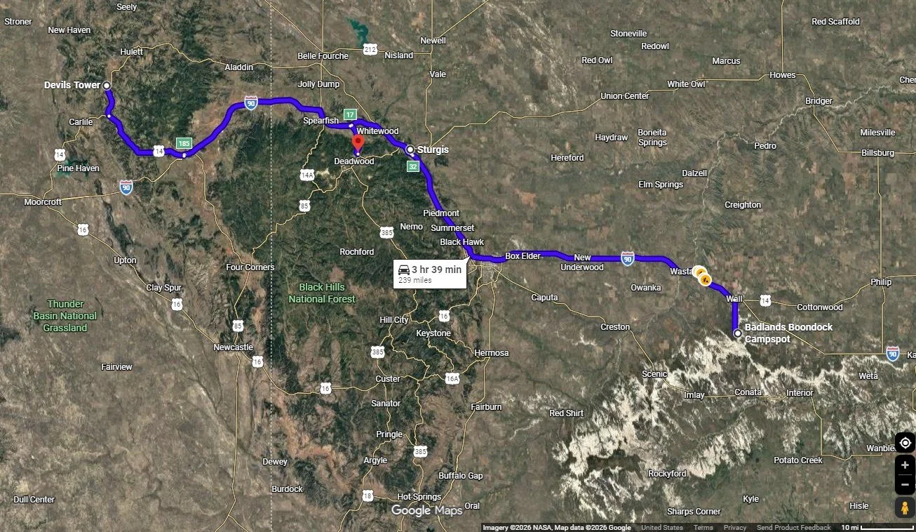
Full Day of Driving Around on Day Three, mapped in Google Maps
The Black Hills
The Black Hills are known as Paha Sapa to the Lakota Sioux, meaning “hills that are black,” a fitting name for these pine-covered peaks that rise dark and dramatic against the horizon.
The Black Hills rise in a gentle, dome-shaped swell, formed around 70–50 million years ago during the Laramide Orogeny, when ancient layers of rock were pushed up through Earth’s crust. Today, that dramatic past sets the stage for some of the region’s most scenic drives, many of which wind through and around Custer State Park, where granite spires, forested hills, and sweeping vistas unfold around every curve.
Sturgis
Our first stop in the Black Hills was Sturgis, the “City of Riders,” to get a feel for the town as it prepared for the world's largest motorcycle rally, held in early August. It is in Sturgis where we stopped at the grocery store to pick up some food for the campsite, including steak and local beer.
The Sturgis historic town center is a walkable, vibrant downtown hub with local dining, shopping, and a unique atmosphere that celebrates biker culture. Four days before the motorcycle rally, the area was lined with vendors, food stands, and stages.
I hope to return one day to check out the Sturgis Motorcycle Museum & Hall of Fame and peruse the shops selling denim, leather, and patriotic pride.
Bear Butte
I also want to check out the nearby Bear Butte State Park, which is 14 minutes from Sturgis. Bear Butte takes its name from Mato Paha, or “Bear Mountain” in Lakota, and Noahvose, meaning “Giving Hill” or “Where the Cheyenne Are Taught,” in Cheyenne.
Bear Butte is a sacred landmark where Lakota perform vision quests for spiritual guidance, and the Cheyenne believe the prophet Sweet Medicine received sacred knowledge, foundational laws, and the Four Sacred Arrows from the Creator at Bear Butte.
Bear Butte is a classic example of a laccolith, which is an intrusive igneous rock formation. It formed when molten magma forced its way between horizontal layers of sedimentary rock, causing them to bulge upward into a dome. Because this magma solidified underground rather than erupting, erosion later exposed it to a prominent, dome-shaped hill.
Devil’s Tower
Deadwood was the main destination on day three, but we made time to stop at Devil's Tower, the 867-foot monolith rising out of Wyoming's prairie that our daughters had to see in person. Known as Mato Tipila in Lakota, meaning "Bear Lodge," it was designated the nation's first national monument by Theodore Roosevelt in 1906. It’s as striking in person as it is in photos.
We took in the view from the picnic area before deciding to get a closer look, but the line for the main visitor center’s parking lot barely budged. Summer parking here is tight, so we decided to move on since my husband and I had been there before, and the girls didn’t mind. We turned around and watched the prairie dogs before leaving the park for the Tatanka: Story of the Bison Museum.
The detour to Devil’s Tower cost us a few extra hours, but we also made a stop at the Northeast Wyoming Visitor Center off I-90. Our daughters made the most of the photo opportunities scattered throughout the exhibits, while I stocked up on travel information.
Quick side note: if you’re looking for deeper history and more detailed info on many of the stops described, please check out my South Dakota and Nebraska videos and blogs at Travel Guides from Kris.
Tatanka Story of Bison
Just off Highway 85 on the way into Deadwood, the Tatanka: Story of the Bison is an easy, worthwhile stop, even if the ticket price feels a bit steep. The site serves as a memorial and education center dedicated to the bison. It is anchored by dramatic, larger-than-life bronze sculptures behind the building, created by Peggy Detmers, titled the Lakota Bison Jump. The three-dimensional artwork accompanying the museum illustrates a buffalo hunt featuring 14 bison pursued by three Lakota riders.
The interpretive center was inspired by Kevin Costner, who wanted to share the impact the Northern Plains had on him during the filming of Dances with Wolves. Inside, you’ll also find original pieces from the film on display.
The cultural center’s focus is on the history and near extinction of the bison, as well as their significance to Native American culture and daily life.
It’s a powerful reminder of how quickly things change. In the early 1800s, roughly 60 million bison roamed the plains. By 1889, fewer than 1,000 remained due to overhunting. Today, conservation efforts have helped their numbers rebound to around 500,000, with several Black Hills parks maintaining thriving herds.
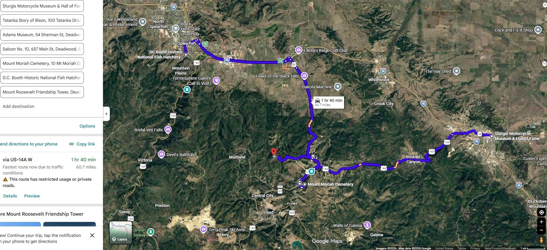
Destinations around Deadwood, Mapped in Google Maps
Days of ‘76 and the Adams Museum
Just minutes down the hill at the junction of Highways 85 and 14A, the Days of '76 Museum drops you straight into 1876, the rowdy, gold-rush year that put Deadwood on the map. It was here that 25,000 fortune seekers flooded the gulch, and where Jack McCall shot Wild Bill Hickok during a poker game in one of the West’s most infamous moments. Today, the museum brings that frontier energy to life while celebrating the annual Days of ’76, an elite rodeo and festival held each July. Inside, exhibits preserve the spirit of the Black Hills with artifacts ranging from horse-drawn wagons and stagecoaches to classic rodeo memorabilia.
We skipped the museum this time, but plan to visit on our next trip. Instead, we headed into Deadwood to explore the Adams Memorial Museum.
The center preserves and displays exhibits that bring the story of the Black Hills to life, from Native American culture and gold rush days to the larger-than-life legends of the Wild West. Even better, the museum offers a kid-friendly scavenger hunt that turns wandering through the exhibits into a fun, hands-on adventure.
The Company Deadwood History Inc operates the Days of 76’ Museum and Adams Museum, as well as the Brothel Deadwood and the Historic Adams House.
Deadwood
After the Adams Museum, we wandered into the Deadwood Historic District to take in the energy of Main Street. It is a breathtaking step into a bygone era, a place where the legends of Deadwood Dick, Wild Bill, and Calamity Jane are woven into the very timber and storied streets of this untamed frontier. Today, beautifully restored buildings, many revived by casino revenue, blend Old West grit with a lively, modern edge, where more than 20 casinos now light up the historic strip.
At Saloon No. 10, we caught a reenactment of Jack McCall’s capture, part of a summer series staged three times daily, Monday through Saturday. The bar leans into its legend as the site where Hickok was shot mid–poker hand in 1876, adding an extra layer of drama to the experience.
The action spills onto the street with the Deadwood Alive Main Street Shootout, where actors recreate some of the town’s most infamous gunfights. Among them is the brutal 1877 clash between Tom Smith and David Lunt, a story made even more unbelievable by the fact that Lunt survived for 67 days after being shot before finally succumbing. You can find the full list of showtimes and details on their official social media or at DeadwoodAlive.com.
Before leaving Deadwood on Day Four, we visited Mount Moriah Cemetery to see the graves of iconic Wild West legends and enjoyed panoramic views of the town below.
We didn't make it to the Broken Boot Gold Mine or the Adams House on this trip. Both are on our radar for next time, as each offers a deeper look into Deadwood's rich and storied past.
For a fun keepsake, Woody's Wild West Portrait Emporium is within walking distance of the historic corridor. As the country's longest-running old-time photo studio, it features more than 25 authentic historical sets and over 1,000 costume combinations for all ages.
If you are interested in car shows, check out Kool Deadwood Nites, held each year in late August. The event includes live music and activities and serves as a major fundraiser supporting the preservation of historic Deadwood.
From Deadwood, we traveled to the DC Booth National Fish Hatchery, founded in 1889. This site helped establish trout populations throughout the Black Hills, restoring fish stocks depleted by overfishing and industrialization. Today, it’s a free, scenic stop where you can feed thousands of trout, explore the Victorian Booth House, and see a restored fisheries rail car.
While our daughters napped, my husband and I traded off on the short, sub-mile loop up to the Mount Roosevelt Friendship Tower. Built in 1919 by Deadwood sheriff Seth Bullock as a tribute to his friend Theodore Roosevelt, the stone tower feels quietly tucked into the hills. The climb is easy, but the payoff is big, wide-open views stretching out to Bear Butte on the horizon.
Just down Roosevelt Road, you’ll also find free dispersed camping scattered throughout Black Hills National Forest, a simple, scenic spot if you’re looking to stay close to it all. Remember that roads in the National Forests are rough and can be challenging, especially after rain, so you should have a four-wheel-drive vehicle if you choose to explore them.
On the drive from Deadwood to Spearfish Canyon, the road winds through Lead, a mile-high town shaped by gold and grit. Here, the Sanford Lab Homestake Visitor Center opens to a sweeping view of the massive Open Cut, its walls plunging 1,250 feet into the earth, while exhibits trace the quiet shift from gold mining to underground science.
Just a minute down the road, the Black Hills Mining Museum takes you deeper into the past, with a simulated mine tour and stories from the 1876 gold rush that still echoes through these hills.
Now we head deeper into the Black Hills, where the scenery turns raw and intimate. Spearfish Canyon slips into steep limestone walls, and Custer State Park drops you right into the rugged heart of it all.
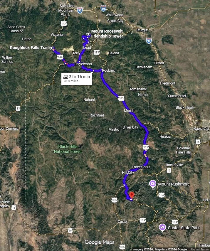
Deadwood to Spearfish Canyon to Custer State Park, Mapped in Google Maps
Spearfish Canyon
After leaving Lead, the route joins the Spearfish Canyon Scenic Byway (U.S. Highway 14A), a roughly 20-mile stretch connecting Cheyenne Crossing, a historic landmark and popular stop, to Spearfish. The road winds into a deep, narrow gorge carved by Spearfish Creek, tracing the path of an old railroad line that was washed out and abandoned after the floods of 1933. Spearfish Canyon feels like a truly meeting place of landscapes, where plants from the Rocky Mountains, eastern woodlands, northern forests, and the Great Plains come together in an outstanding, majestic corridor.
Along the way, we took two short, accessible nature walks. The Roughlock Falls Trail, often accessed near the Spearfish Canyon Lodge, features a multi-tiered waterfall cascading down a 50-foot limestone ledge. Nearby, the trail to the serene Spearfish Falls, an approximately 47-foot waterfall, starts behind the Latchstring Restaurant and descends to the canyon floor.
The Spearfish Canyon Scenic Byway features breathtaking stops, including the 60-foot Bridal Veil Falls, which peak in spring but offer a peaceful, dramatic view from an observation deck across from an off-the-highway parking lot.
If you’re looking to escape the crowds, Eleventh Hour Gulch is tucked deep in Spearfish Canyon, perfect for a little adventure off the beaten path! This narrow, shaded route stays cool year-round and climbs quickly through dramatic rock walls, with just enough challenge to keep it interesting. It’s especially striking in winter, when the waterfalls freeze into quiet, sculpted ice, turning the whole place into something a little surreal.
Next, we headed to Custer State Park for a three-night camp at Sylvan Lake, followed by a night at the Custer State Park Game Lodge campground.
Custer State Park is one of those rare places that feels every bit as grand as a national park. Spanning 71,000 acres, it's one of the largest state parks in the country, with room to roam, scenery that never lets up, and better access to scenic drives like Iron Mountain Road, Needles Highway, and Wildlife Loop Road.
The park is home to a herd of more than 1,400 free-roaming bison, and it’s not uncommon to spot pronghorn, elk, bighorn sheep, prairie dogs, and even the friendly, curious burros, so keep your camera close.
For a little surprise, keep an eye on the cliffs. Mountain goats, native to Canada, made their home here after an escape in 1924 from the Custer State Park Zoo. Today, you’ll often find them perched high above the trails near Black Elk Peak and the Cathedral Spires, moving across the granite as if it were second nature.
The landscape here feels bold and cinematic at every turn. Cruise the Needles Highway as it winds between soaring pinnacles, pause along the calm, reflective shores of Sylvan Lake, and soak in the rolling, pine-covered hills that give the park its rugged character.
To truly immerse yourself in this landscape, I highly recommend hitting the trails. Wandering through the ponderosa-dotted hills and open prairies is the best way to spot local wildlife and get up close with the park’s unique geology.
And if you would rather experience it on horseback, Blue Bell Stables offers guided trail rides and pony rides from mid-May through September, with one-hour rides through the scenic French Creek Nature Area and two-hour backcountry rides for those wanting a longer adventure. Professional wranglers lead each group, so no prior experience is needed, and "Lil' Buckaroo" pony rides are available for children under 7. Call ahead to secure a reservation, as walk-ins are not always guaranteed.
Custer State Park is named for Lt. Col. George Armstrong Custer, who led a military and scientific expedition into the Black Hills in 1874. After gold was discovered, settlers flooded the region, violating an 1868 treaty that had reserved 60 million acres for the Sioux. In 1876, Crazy Horse and his warriors defeated Custer’s troops at the Battle of the Little Bighorn, one of the era’s defining conflicts. Today, the same rugged landscape that shaped this history invites visitors to explore at a slower pace.
Peter Norbeck Scenic Byway
Beyond the Spearfish Canyon Scenic Byway, three additional scenic drives showcase the region's dramatic beauty. The Needles Highway (SD 87), Iron Mountain Road (US 16A), and the Wildlife Loop Road in Custer State Park make up the 70-mile Peter Norbeck National Scenic Byway.
The Peter Norbeck Scenic Byway is a can’t-miss loop, an almost roller-coaster ride through towering pines, granite spires, and sweeping mountain vistas that unfold around every curve. Much of what makes this region so special can be traced back to Peter Norbeck himself, a former governor and U.S. senator who helped shape the Black Hills as we know them today, from championing Mount Rushmore to preserving Custer State Park and even scouting routes like Iron Mountain Road on horseback.
The oval-shaped byway connects the area's most iconic destinations and is best driven unhurriedly to take in every twist, turn, and tunnel along the way. If you are traveling in an RV, pay close attention to clearances throughout the route. Needles Highway and Iron Mountain Road have strict vehicle height and width limits due to their narrow tunnels, generally requiring vehicles to be under 11 feet high and 8'4" wide at the tightest points. Large RVs, long trailers, and wide buses are generally advised against these routes, though small camper vans may pass with extreme caution.
If you are traveling in an RV or prefer to sit back and take it all in, Custer State Park Resort offers dedicated Scenic Byway Tours covering both the Needles Highway and Iron Mountain Road, a great way to experience these narrow, tunnel-filled routes without getting behind the wheel yourself. Also, keep in mind that portions of the byway, including the Needles Highway and Iron Mountain Road, typically close from mid-October through early April due to snow, so be sure to plan your visit accordingly.
Needles Highway
The 14-mile Needles Highway is one of those drives you won’t forget, a twisting, climbing route that takes you straight through a forest of jagged granite needle-like formations. Reaching elevations of around 6,200 feet, this thrilling stretch of road winds deep into the rugged heart of the Black Hills, delivering dramatic overlooks, tight curves, and eye-level views of the region’s most iconic rock formations.
It’s not a road for the faint of heart; you’ll want to take it slow and stay alert. There are sharp switchbacks and narrow tunnels, including the famous Needles Eye Tunnel (just 8’4” wide and 11’3” high).
Come winter, Needles Highway transforms completely. The road is closed to vehicles and is specially used for winter recreation, becoming a quiet playground for snowshoeing, hiking, and cross-country skiing, an entirely different way to experience this striking landscape.
Iron Mountain Road
Iron Mountain Road (Highway 16A) is a 17-mile scenic drive that feels less like a road and more like a slow-moving thrill ride linking Mount Rushmore to Custer State Park. With an incredible 314 curves, 14 switchbacks, three iconic wooden pigtail bridges, and three narrow tunnels, it twists and loops its way through sun-dappled pine forests in the most unforgettable way.
Wildlife Loop
What makes this drive truly special are the perfectly placed tunnels that frame Mount Rushmore in the distance, each one revealing a surprise view you won’t see coming. It’s a road designed for the journey, not the destination.
The Wildlife Loop Road is an 18-mile scenic drive through Custer State Park and is a must-do for anyone visiting the Black Hills. The route winds through sweeping golden grasslands and open prairie, passing over rustic stone bridges and rolling through pine-dotted hills. This is an easy, slow-paced drive; the road is fully paved, well-maintained, and wide enough to accommodate trailers and larger rigs comfortably.
The Wildlife Loop Road offers some of the best wildlife-viewing opportunities in the entire Black Hills region. Bison roam freely along the route, and you may also spot elk, mule deer, pronghorn antelope, prairie dogs, bighorn sheep, and the park's famous begging burros.
Sylvan Lake
On day five, we stopped at the stunning Sylvan Lake, the Crown Jewel of Custer State Park, where massive granite boulders frame deep blue waters. Interestingly, the lake is actually man-made, created in 1891 when a dam was built across Sunday Gulch Creek.
A one-mile scenic loop trail circles the shoreline, making for an easy, family-friendly hike with constant lake views and plenty of spots to climb the rocks or pause for photos. For those looking to go a bit farther, Sylvan Lake also serves as a trailhead for more adventurous routes like the Sunday Gulch Trail and access to Black Elk Peak, two of the most popular hikes in the Black Hills. And if you're visiting in warmer months, you can even take a refreshing swim in the pristine lake, surrounded by its iconic granite formations.
While my husband and daughters fished for trout, I did the laundry in the machines near the Coolidge General Store and the cabins. The General Store is spacious, with plenty of souvenirs and a food stand. You can also rent canoes, kayaks, and stand-up paddleboards from the store, conveniently located on the side of the building near the water. At Sylvan Lake, cell phone reception is almost nonexistent, but a short drive up the hill to the Sylvan Lake Lodge brings you back in range. The lodge also features a restaurant.
On Day two of our stay at the Sylvan Lake Campground, we explored two of the Black Hills’ most notable cave systems: Jewel Cave National Monument and Wind Cave National Park.
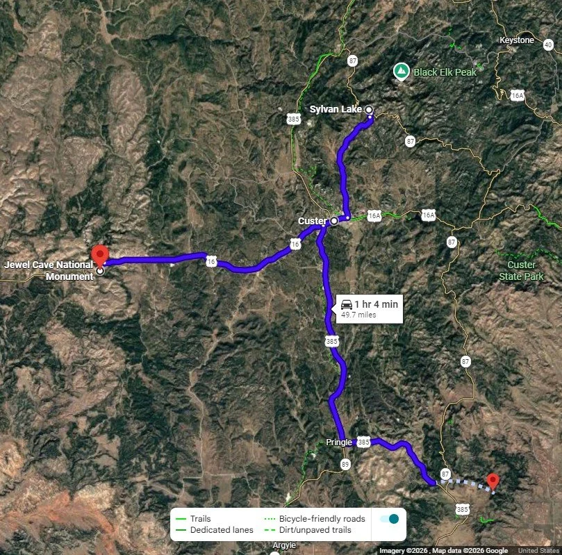
Sylvan Lake to Jewel Cave National Monument and Wind Cave National Park, Mapped in Google Maps
Jewel Cave National Monument
Just about 30 minutes from Sylvan Lake, Jewel Cave National Monument makes for an easy and rewarding first stop in the Black Hills. Jewel Cave is one of the longest cave systems on Earth, with more than 220 miles of mapped passageways still being uncovered. The highlight comes as you descend into its depths, where glittering calcite crystals, known as the cave’s “jewels”, line the walls in delicate, unexpected beauty.
A ranger-guided tour is required to explore the cave, and the park offers four options. The Historic Lantern Tour takes you through the cave by lantern light, the Wild Cave Tour is a strenuous crawl through undeveloped passages, and the short Discovery Tour is a great introduction for first-timers. The Scenic Tour is the most popular of the four. It’s a moderately strenuous one-hour-and-20-minute journey that descends 734 steps into one of the most striking subterranean landscapes in the Black Hills.
We chose to do the Scenic Tour and enjoyed the experience. Wear sturdy shoes regardless of which tour you choose, as the steps and passages can be uneven and slippery in places.
Custer City
In between Jewel Cave National Monument and Wind Cave National Park, a stop in Custer is convenient for lunch and supplies. The town’s Main Street features a series of nearly life-sized, hand-painted buffalo sculptures, remnants of the Custer Stampede Art Auction, that reflect local history and regional artistry.
Custer’s historic Dr. Flick Cabin is one of the oldest buildings still standing in the Black Hills. The frontier cabin is in the quaint Way Park, which is home to the town’s farmers market as well as the Monument dedicated to Horace N. Ross, the person who discovered Gold in Custer on July 27, 1874.
In 1875, Dr. Daniel W. Flick began building the cozy cabin that still stands today. Dr. Flick was an early settler and physician who lived and ran his medical practice from 1876 into the early 1900s, caring for miners, loggers, and other early residents of the Black Hills.
Over the years, it became a haven for pioneers, served as the base for Captain Edwin Pollock’s military operations, and sheltered the famed frontiersman Captain Jack Crawford.
In downtown Custer, the surprisingly extensive 1881 Courthouse Museum is worth a stop if you have time. Housed in the original Dakota Territory courthouse, built before South Dakota was even a state, the museum spans three floors of exhibits covering Southern Black Hills history, including Native American culture, gold mining, and General Custer's 1874 expedition.
Wind Cave
Just 20 minutes from Custer, Wind Cave National Park draws you in with a quiet kind of wonder, protecting 44 square miles of rolling grassland and ponderosa pine forest just south of Custer State Park. The park is anchored by its namesake cave, an underground labyrinth with more than 147 miles of mapped passages, one of the longest and most complex cave systems in the world.
Several tour options are available depending on the season, and we chose the Natural Entrance Tour, which begins at the small opening in the cave's surface, where steady gusts of air rush in and out with atmospheric pressure, the phenomenon that gives the cave its name.
A man-made passage leads into the depths below, where the cave's true character emerges in its rare and intricate boxwork formations. These delicate, honeycomb-like calcite fins, estimated at roughly 60 million years old, represent approximately 95% of all known examples on Earth, giving the cave an ethereal, ancient quality found nowhere else quite like it.
Beyond its geology, Wind Cave holds deep cultural significance. The Lakota know it as Maka Oniye, meaning "breathing earth" and regard the cave's natural entrance as a sacred site central to their Emergence Story, the oral tradition that identifies this place as where their ancestors and the first bison passed from the spirit world into the physical world. For the Lakota, this is not a geological curiosity but the literal birthplace of their nation.
Tours sell out quickly, and reservations through Recreation.gov are strongly recommended; same-day tickets are limited and not guaranteed.
Above ground, the park rewards equally. The Wind Cave Canyon Trail, a 3.6-mile round trip, winds through open prairie and along a canyon rim where bison graze, and prairie dogs call out from their colonies, with wide-open views stretching beneath a vast South Dakota sky. Three additional one-mile round-trip trails offer shorter escapes: the Rankin Ridge Nature Trail climbs to the park's highest point for panoramic views, the Elk Mountain Trail threads through a peaceful grassland-forest mix near the campground, and the Prairie Vista Trail departs directly from behind the visitor center as an easy introduction to the surrounding ecosystem.
Elk Mountain Campground offers the park's only overnight option: 62 non-electric sites at $24 per night. Fees may change over time, so it's worth confirming current rates before you go.
Our campsite near Sylvan Lake is roughly 35 miles north of Wind Cave National Park. Wind Cave backs directly up against the southern border of Custer State Park, with the park's Wildlife Loop Road running through the prairie sections further east. Because there are no high-fence borders, animals wander freely across the two parks.
Crazy Horse Memorial
Rather than heading straight back to the campsite, we decided to push a little further and loop through Keystone, which took us past the Crazy Horse Memorial. We pulled over near the entrance for a breathtaking look at the massive mountain carving and plan to make a full, dedicated visit next time to explore the museums and grounds in depth.
Even unfinished, the memorial is impossible to miss along Highway 16. When complete, it will stand 563 feet tall. It depicts the Oglala Lakota warrior Crazy Horse on horseback, pointing towards his ancestral home, symbolizing his defiance and connection to the land. The project came to life after Lakota elder Standing Bear personally asked sculptor Korczak Ziolkowski to memorialize Crazy Horse. Ziolkowski turned down millions in federal funding to keep the project free from government interference.
Indoors, visitors can watch an orientation film, tour the sculptor's studio, and witness history in the making, a unique experience compared to the finished monuments nearby. The site also hosts Native artisans, dancers, and musicians.
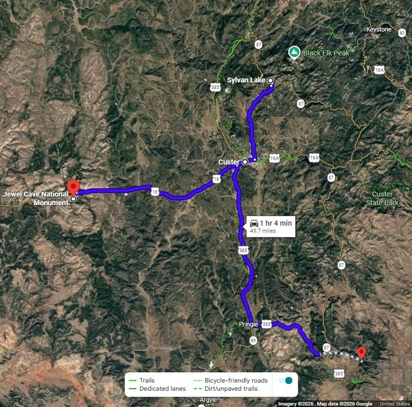
From Wind Cave, driving to see the Crazy Horse Memorial, Keystone, and Iron Mountain Road, mapped in Google Maps
Keystone
From the Crazy Horse Memorial, we made our way into Keystone to visit Dahl's Chainsaw Art, a roadside gallery featuring massive wood sculptures created by artists Jarrett and Jordan Dahl. Carved from local ponderosa pine, the collection includes bears, eagles, motorcycles, and their most iconic piece, a 23-foot award-winning "World's Largest Wooden Bigfoot." We walked through the outdoor gallery, took in all the incredible carvings, and ended up buying a beautiful wooden cross with barbed wire and roses.
Keystone gives you easy access to Mount Rushmore and puts you right at the doorstep of scenic Iron Mountain Road, making it a great base for exploring the area. The town itself has plenty of attractions worth adding to your itinerary, offering a solid mix of outdoor adventure, Gold Rush history, and western-themed shopping.
Iron Mountain Road
From Keystone, we drove Iron Mountain Road on our way back to camp, but if you’re planning this iconic drive, a little strategy goes a long way.
For the best experience, drive it north to south, starting in Custer State Park. This direction lines up the three famous tunnels so they perfectly frame Mount Rushmore in the distance, something we missed this day by driving the opposite way.
Before you go, plug key stops like the Doane Robinson Tunnel and Norbeck Overlook into your GPS so you don’t miss them. Other highlights along the route include the CC Gideon and Peter Norbeck tunnels, along with the scenic Iron Mountain Picnic Area. The narrow, winding tunnels are easily the most memorable part of the drive, and knowing when they’re coming up makes the experience much more rewarding.
Little Devils Tower Trail
We began Day Seven with a hike on the Little Devils Tower Trail (#4), a moderate 3.8-mile out-and-back that connects directly to the Black Elk Peak Trail (#9) and the Cathedral Spires Trail (#4A). On its own, Little Devils Tower is a manageable hike, but if you link it with Cathedral Spires and Black Elk Peak, it becomes a much longer, more strenuous 8-mile loop, one of the most popular and rewarding hikes in the Black Hills.
The trailhead parking lot for Little Devils Tower is located along Needles Highway, about 0.7 miles past the Sylvan Lake turnoff. However, if you plan to complete the full Black Elk Peak–Cathedral Spires loop, it’s easiest to park at Sylvan Lake and start from there. The Little Devils Tower portion gains around 700 feet in elevation, with some rocky sections near the summit that require light scrambling.
Our hike was blanketed in fog, but the payoff at the summit was still incredibly rewarding. From the top, you get sweeping, 360-degree views that stretch across ponderosa pine forests, the jagged vertical granite pillars of Cathedral Spires, a National Natural Landmark, and out toward Black Elk Peak. On a clear day, you can even spot the historic fire lookout tower on the summit, with the southern Black Hills unfolding in every direction. Dogs on a leash are welcome, and with restrooms and a general store nearby, Sylvan Lake makes a convenient and well-equipped base for the hike.
Black Elk Peak was renamed in 2016 to honor Lakota Sioux spiritual leader Nicholas Black Elk, replacing Harney Peak, a former name tied to a U.S. Army general associated with a 19th-century massacre.
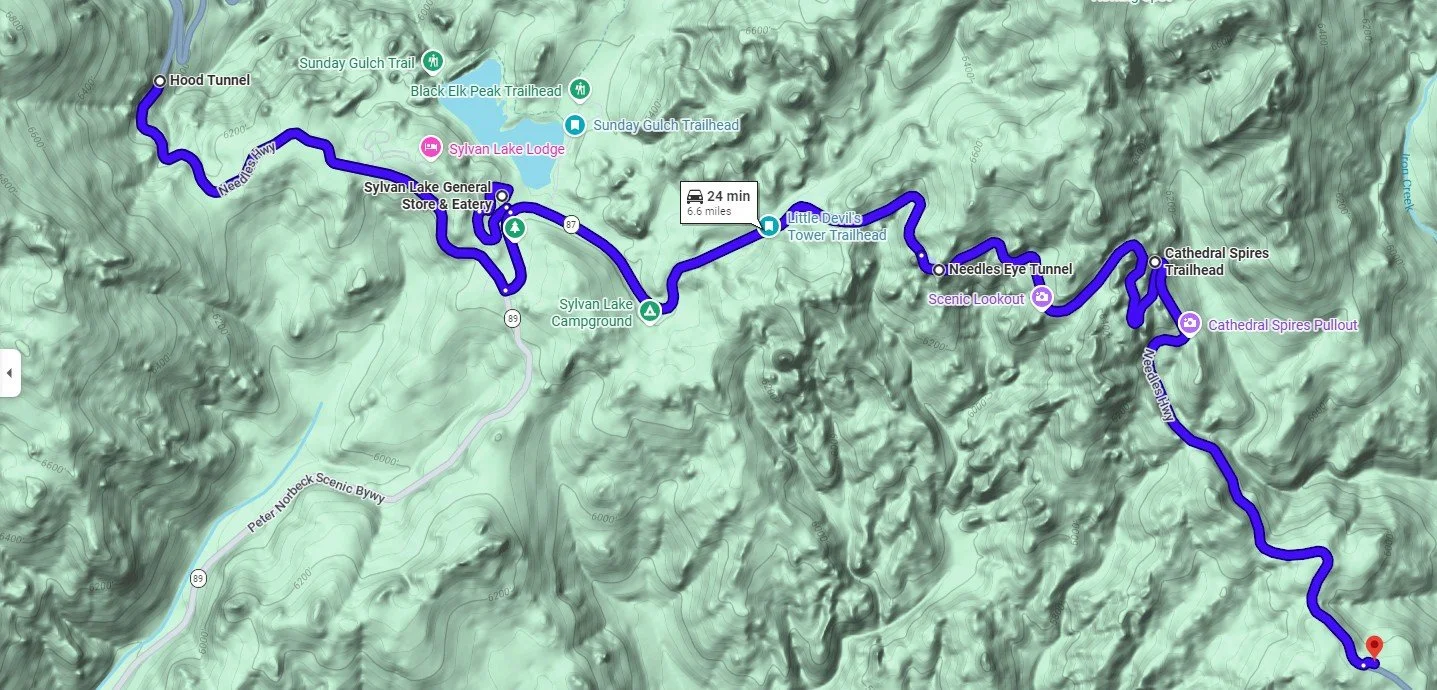
Attractions, trailheads, and lookouts along Needles Highway in Custer State Park, mapped in Google Maps
Needles Highway
After the hike, we spent the rest of the day exploring Needles Highway, stopping at the Game Lodge Visitor Center, and continuing through the Wildlife Loop before settling in for the evening at the Game Lodge Campground.
You can begin Needles Highway at Sylvan Lake, heading just a few miles north on SD 87 to encounter the Hood Tunnel, a narrow, one-lane passage cut through solid rock. As you drive through, the tunnel perfectly frames a striking view of the spires beyond, making it an ideal first glimpse of the engineering that defines this road. After passing through, turn around and head south on SD 87 for 14 miles through a dramatic landscape of towering granite spires, planning a few more stops along the way
The Needles Eye Tunnel and Rock Formation is a must-see, with its tight passage and iconic needle-like spires; the Cathedral Spires Trail offers a chance to stretch your legs with a hike among those striking granite formations; and the Needles Scenic View provides a perfect pull-off for soaking in the sweeping vistas.
From the junction of US-16A and SD-87 near the Game Lodge, you can continue to the Wildlife Loop Road for incredible wildlife viewing. Or head east and then north on US-16A toward Mount Rushmore to connect with Iron Mountain Road, known for its famous tunnels and winding pigtail bridge.
Before we headed out to do any more exploration, we stopped at the Game Lodge Visitor Center in Custer State Park. The staff is knowledgeable and helpful, and it's a great place to pick up a trail map, get current road and wildlife conditions, and learn more about the park's history. During our visit, the staff pointed us to where the bison and burros on Wildlife Loop Road were last seen.
If you have time to explore further, there is plenty more to see nearby. The historic State Game Lodge, once the Summer White House for Presidents Calvin Coolidge and Dwight D. Eisenhower, is worth a stop and offers lodging, dining, and jeep safari tours into the park.
Behind the Game Lodge, the Lovers' Leap Trail is a moderately challenging 4.2-mile loop with the trailhead tucked behind the old schoolhouse. The trail winds through the woods along a stream before climbing to sweeping views of the creek valley, surrounding ponderosa pine hills, and Mount Coolidge.
The Peter Norbeck Education Center is a great resource for learning more about the natural history and wildlife of Custer State Park before heading out to explore.
Wildlife Loop
The 18-mile Wildlife Loop Road in Custer State Park offers one of the best chances in the Black Hills to see free-roaming wildlife. Bison, pronghorn, bighorn sheep, mule deer, and prairie dogs move through the area at will, and the famously friendly wild burros are known to wander right up to your car looking for a handout.
The road is fully paved and wide enough to accommodate larger vehicles, winding over charming historic stone bridges and through panoramic, expansive landscapes. Plan to take it slowly, keep an eye out for wildlife jams, and go early in the morning or just before sunset for the best wildlife activity.
For an even closer look, the guided Buffalo Safari Jeep Tours take you off the main roads and deeper into the herded areas for up-close encounters. And if you are planning a fall visit, do not miss the annual Buffalo Roundup, typically held in late September. Watching park rangers and cowboys gather and move nearly 1,300 bison across the open prairie is one of those rare, larger-than-life Western experiences.
If you're looking for a fun evening activity, the Black Hills Playhouse, hosted by Theatre 605, is a charming and unexpected find tucked inside Custer State Park. Located near Center Lake along South Playhouse Road, just off Iron Mountain Road (Highway 16A) and Needles Highway (Highway 87). The theater has been staging professional productions in the Black Hills since 1946. Shows run from June through August and feature Broadway-style musicals, comedies, and popular plays in an intimate 340-seat venue, making it a great way to wind down after a full day of exploring.
We started Day Eight with another pass through the Wildlife Loop Road, taking our time and hoping to spot what we may have missed the first time around. From there, we made our way to Mount Rushmore for a proper visit before stopping at Horse Thief Lake on the way back, a scenic, peaceful spot. And then we wrapped up the evening back at our campsite.
Mount Rushmore National Memorial
Mount Rushmore National Memorial is an undeniably impressive sight. Gutzon Borglum's 60-foot granite carvings of four American presidents emerging from the mountainside are something you must see in person to fully appreciate. The four presidents- George Washington, Thomas Jefferson, Abraham Lincoln, and Theodore Roosevelt- were chosen to represent the most significant chapters in American history, from the nation's founding and expansion to its preservation and rise as a world power. The Avenue of Flags leading up to the memorial, representing all 50 states and U.S. territories, sets the stage nicely before you even reach the viewing area. Once there, two short walks are worth your time: the Presidential Trail loop brings you to the base of the mountain for a closer look at the sculpture, while the Sculptor's Studio Trail offers a peek into the tools and techniques Borglum used to bring the carvings to life. For the best light and fewer crowds, try to arrive early in the morning.
A visit to Mount Rushmore is even more meaningful when you take a moment to understand the land's deeper history. To the Lakota Sioux, this was never Mount Rushmore; it was Paha Sapa, or the Six Grandfathers, a sacred landscape used for generations for ceremonies, prayer, and gathering resources. For the Lakota and other tribes, the Black Hills were considered the spiritual center of the universe, making this one of the most culturally significant regions in North America. That history is an important part of the full story of this place, and one worth seeking during your visit.
The National Park Service offers on-site interpretive programming, including the Lakota, Nakota, and Dakota Heritage Village, which shares the stories of the Native peoples who called the Black Hills home long before European settlement. Village tours are typically offered on summer afternoons, though times vary by day. Unfortunately, I didn’t realize until the day of my visit that the tours weren’t running.
For a lighter piece of Rushmore trivia, film buffs may recall the monument in Alfred Hitchcock's classic thriller North by Northwest, where it features prominently in the film's dramatic final scenes.
Side note: your Mount Rushmore parking ticket is valid for a full year
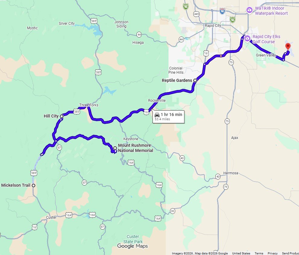
Drive through the Black Hills: Mickelson Trail, Hill City, Mount Rushmore, and Rapid City, mapped in Google Maps
Additional Black Hills Attractions
As you make your way out of the Black Hills, there are several fun stops worth weaving into your drive heading out or towards Rapid City.
The George S. Mickelson Trail is widely regarded as one of the most rewarding ways to experience the Black Hills. This 100-mile-plus Rails-to-Trails route follows a former railroad corridor, crossing more than 100 bridges and passing through four tunnels. With 15 trailheads, it's easy to explore in sections, and the gentle 4% grade makes it approachable, though distance and wind can still add a challenge. Keep in mind that a trail pass is required. George S. Mickelson Trail bike rentals are easy to arrange, with several full-service outfitters stationed directly on or near the trail. Most carry both traditional and e-bikes, sell trail passes, and run shuttle services that drop you at one end so you can ride back at your own pace. It is already on our radar for a future family visit, and from everything I can imagine, it sounds like a trip worth planning around.
Hill City is a charming old gold rush town with a couple of worthwhile stops to consider adding to your itinerary. The Black Hills Central Railroad offers a nostalgic steam train ride through the ponderosa pines on the historic 1880 Train, which once carried gold mined in the Black Hills, and it typically runs from May through October. Tickets are known to sell out quickly during peak summer months, so booking in advance is recommended. Art lovers will also want to pop into the Jon Crane Gallery, which showcases stunning watercolors of South Dakota life by one of the region's most celebrated artists.
Further along U.S. Highway 16, Bear Country USA and Reptile Gardens are classic old-school roadside attractions that have entertained visitors for generations. Bear Country USA is a drive-through wildlife park where you can spot black bears, elk, reindeer, and cougars roaming freely from the comfort of your car. Note that Bear Country USA is closed during the winter months. Just down the road, Reptile Gardens is home to the world's largest reptile zoo, with around 225 species and subspecies and a surprisingly hands-on experience that lets you get up close to everything from snakes and lizards to massive tortoises and crocodiles. The Dinosaur Museum next door is also a great option, featuring life-size dinosaur replicas, real fossils, a mirror maze, a simulated fossil dig for kids, and an education theater.
Best of all, each of these stops lies conveniently along the main route between popular Black Hills destinations, making them easy to add without much backtracking.
As you make your way out of the Black Hills, there are several fun stops worth weaving into your drive heading out or towards Rapid City.
The George S. Mickelson Trail is widely regarded as one of the most rewarding ways to experience the Black Hills. This 100+ mile Rails-to-Trails route follows a former railroad corridor, crossing more than 100 bridges and passing through four tunnels. With 15 trailheads, it's easy to explore in sections, and the gentle 4% grade makes it approachable, though distance and wind can still add a challenge. Keep in mind that a trail pass is required. It is already on our radar for a future family visit, and from everything I can imagine, it sounds like a trip worth planning around.
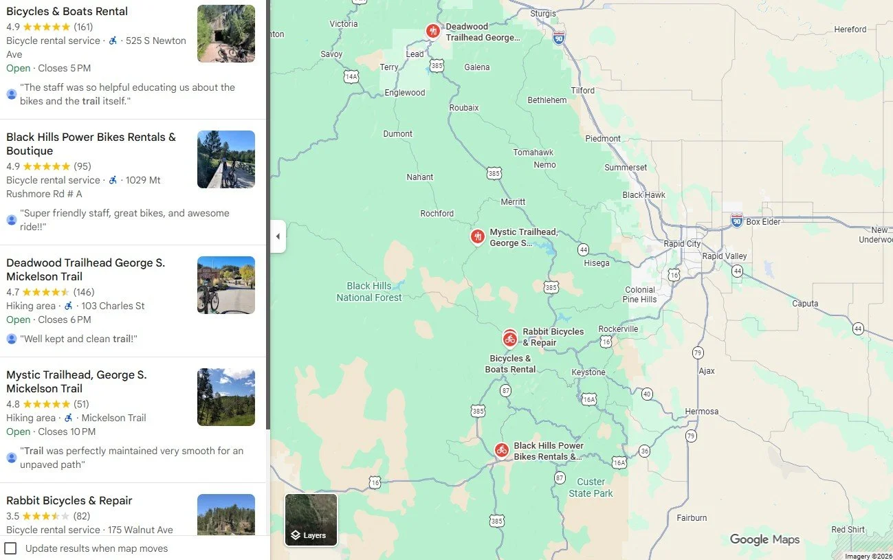
Bike rental locations and George S. Mickelson Trail trailheads in the Black Hills, mapped in Google Maps
Hill City is a charming old gold rush town with a couple of worthwhile stops to consider adding to your itinerary. The Black Hills Central Railroad offers a nostalgic steam train ride through the ponderosa pines on the historic 1880 Train, which once carried gold mined in the Black Hills, and it typically runs from May through October. Tickets are known to sell out quickly during peak summer months, so booking in advance is recommended. Art lovers will also want to pop into the Jon Crane Gallery, which showcases stunning watercolors of South Dakota life by one of the region's most celebrated artists.
Further along U.S. Highway 16, Bear Country USA and Reptile Gardens are classic roadside attractions that have entertained visitors for generations. Bear Country USA is a drive-through wildlife park where you can spot black bears, elk, reindeer, and cougars roaming freely from the comfort of your car. Keep your windows closed throughout and avoid lingering too long in the bear enclosure. Note that Bear Country USA is closed during the winter months. Just down the road, Reptile Gardens is home to the world's largest reptile zoo, with around 225 species and subspecies, and offers a surprisingly hands-on experience that lets you get up close to everything from snakes and lizards to massive tortoises and crocodiles. The Dinosaur Museum next door is also a great option, featuring life-size dinosaur replicas, real fossils, a mirror maze, a simulated fossil dig for kids, and an educational theater.
Best of all, each of these stops lies conveniently along the main route between popular Black Hills destinations, making them easy to add without much backtracking.
Rapid City
Before moving on to the Badlands, we spent a little time in Rapid City, which is well worth a stop. As the main gateway to the Black Hills and home to the region’s primary airport, it strikes a nice balance between convenience and character, with a welcoming small city feel, a thriving arts scene, and a downtown that still carries a touch of Old West charm. The downtown streets are lined with historic brick buildings, home to locally owned shops and restaurants that make it easy to wander and linger.
One of the city’s most unique features is the City of Presidents, a collection of more than 40 life-sized bronze statues of U.S. presidents placed on street corners throughout downtown. What makes them especially engaging is their attention to detail. Rather than stiff, formal poses, each sculpture captures a more human side of these leaders, highlighting personality traits, quirks, or defining moments. Franklin D. Roosevelt is depicted delivering his “Day of Infamy” address, standing behind a podium with a dense array of radio microphones, and Ulysses S. Grant stands in his Union uniform with his signature cigar tucked behind his back. These small touches make the experience feel surprisingly personal and memorable. The privately funded project began in 2000 and features work by several talented artists. To make the most of your visit, pick up a walking tour brochure at the visitor center or look it up ahead of time to guide you between historic sites and public art. The City of Presidents statues come with an audio tour. Simply call 605-221-4921, enter the statue's unique item number, and listen to each president's story. For example, press 9# for Theodore Roosevelt or 11# for Abraham Lincoln.
On Main Street is the Prairie Edge Trading Company and Galleries, which I wish I had discovered before our visit. From the pictures I have seen online, it looks like a beautiful, culturally rich walk-through. The store showcases both traditional and contemporary Native American art alongside works from local and regional artists.
If you are traveling with kids, Storybook Island is a longtime local favorite and one of Rapid City's most charming stops. Spread across 8.5 acres, this free, whimsical park features over 60 storybook-themed sets, a carousel, a train ride, and plenty of play areas designed to spark imagination.
The Museum of Geology at the South Dakota School of Mines and Technology is also worth a stop. Home to over 250,000 fossils and 6,000 minerals, primarily from the Northern Great Plains, it offers an engaging look at the geological forces that shaped the region, with standout specimens including a T. Rex and rare Cretaceous marine fossils, making it one of the country's premier paleontology collections.
Whether you are passing through or using Rapid City as a base for your Black Hills loop, it is a solid hub with more to offer than most travelers expect.
Badlands National Park
Badlands National Park covers more than 242,000 acres of eroded spires, sweeping canyons, and some of the richest Oligocene-epoch fossil beds on Earth. This terrain is unlike anywhere else in South Dakota. Badlands Loop Road provides the main introduction to the park, while Sage Creek Rim Road and Sheep Mountain Table Road offer a quieter, more remote look at the same landscape. Between the three drives, the park covers enough ground for a full day or more of exploring, along with its trails, campgrounds, and the layered history of the Stronghold District within the Pine Ridge Indian Reservation.
Badlands National Park
Badlands National Park spans more than 242,000 acres and contains the largest undisturbed mixed-grass prairie in the country. The park holds some of the richest fossil beds in the world from the Oligocene epoch, including remains of ancient three-toed horses, saber-toothed cats, and rhinos.
The park was originally authorized as a national monument in 1929 and officially established in 1939, before being redesignated as a national park in 1978.
Layered rock formations of sandstone, siltstone, mudstone, claystone, limestone, volcanic ash, and shale rise from the surrounding grassland, shaped over millions of years into canyons, ravines, gullies, buttes, mesas, and hoodoos.
Compared to the cooler, more humid Black Hills, the Badlands run hot, arid, and sparsely vegetated, with temperatures often running 10 to 20 degrees warmer and significantly less annual precipitation. Light shifts the terrain's color throughout the day, from muted tan and gray tones at midday to layered pink, red, purple, and yellow at sunrise and sunset, making those hours’ worth planning around.
Wildlife in the park includes black-footed ferrets, black-tailed prairie dogs, American bison, bighorn sheep, and pronghorn. Cliff swallows, western meadowlarks, and burrowing owls are common near prairie dog towns, while golden eagles, prairie falcons, and ferruginous hawks are often seen overhead. The venomous prairie rattlesnake and the non-venomous bullsnake and garter snake are also present; give any snake plenty of space and back away calmly if one is encountered, and watch where hands and feet land when hiking near rocks and brush.
Two visitor centers serve the park. The Ben Reifel Visitor Center, at Exit 131 off I-90, is the main access point for the North Unit and offers maps, exhibits, a fossil preparation lab, and a bookstore. The White River Visitor Center serves the South Unit and provides maps, exhibits, and background on the park's connection to Lakota heritage. Services are limited throughout the park, so water, snacks, and a reliable spare tire are worth having on hand before setting out.
Badlands South Unit
The South Unit of Badlands National Park, which includes the Stronghold District, lies entirely within the Pine Ridge Indian Reservation and is owned by the Oglala Sioux Tribe and managed under a special agreement with the National Park Service. The land holds deep significance for the Lakota people and was the site of the last Ghost Dance in December 1890.
In 1942, the U.S. government seized more than 340,000 acres of Oglala Sioux land on the Pine Ridge Reservation, including the Stronghold District, for use as an aerial bombing and gunnery range training pilots from Ellsworth Air Force Base. The seizure forced 125 families to relocate with little notice. Ownership of most of the land was returned to the Oglala Sioux in 1968, though unexploded ordnance from World War II remains scattered across the ground today, particularly in the Stronghold Unit. The area remains largely undeveloped and rich in fossils, with ongoing efforts to transition management fully to the Oglala Sioux Tribe as a dedicated Tribal National Park.
Three Main Badlands Drives
Three drives cover the park: Badlands Loop Road, Sage Creek Rim Road, and Sheep Mountain Table Road, each offering a different look at the landscape.
Badlands Loop Road (SD 240) is a 39-mile paved scenic byway connecting I-90 near Wall to the town of Interior, reachable from I-90 at Exit 110 or Exit 131. It is the only fully paved road in the park and the most accessible route, with more than a dozen designated pullouts and several trailheads along the way. Additional roadside stops worth including on the main loop are the Burns Basin Overlook and the Quinn Road Prairie Dog Town. Plan one to two hours for the drive, more with stops at the overlooks.
Sage Creek Rim Road, a dirt road in the North Unit, offers strong wildlife viewing and open views of the badlands. The road runs west toward the town of Scenic, with four overlooks along the way, including Roberts Prairie Dog Town, Hay Butte Overlook, and Sage Creek Basin Overlook. The free, primitive Sage Creek Campground along this route accommodates tents and smaller RVs. The road is well maintained for most vehicles, though closures can occur after heavy rain.
Sheep Mountain Table Road, a dirt road, lies four miles south of Scenic, tracing the top of a Table Mountain that separates the Sage Creek basin from the White River and straddling the boundary between the park and the Pine Ridge Indian Reservation. The main drive to the Sheep Mountain Table Overlook runs about five miles and is where most visitors stop for the view. Beyond the overlook, the road continues for roughly 2.5 more miles, becoming rougher and requiring a high-clearance, four-wheel-drive vehicle; many visitors instead hike the remaining section as a five-mile round trip, which also reaches the Cedar Butte Trail. The road surface starts as washboard gravel and grows rougher once it crosses onto the Pine Ridge Indian Reservation, where a high-clearance four-wheel-drive vehicle and driving experience are strongly recommended. Avoid the road when wet, respect the site as sacred land used by tribal members, and go prepared for no cell service. Rattlesnakes have been reported in the tall grass at the top of the mesa.
Badlands Trails
Sturdy boots with good ankle support are recommended for hiking in the Badlands, where loose rock, steep drop-offs, and intense ground heat are part of the terrain. Trail options range from short boardwalk strolls to deep backcountry treks.
The North Unit serves as the park's main hub and contains its primary designated trail network. The Notch Trail, a 1.5-mile round-trip route, features a steep wooden log ladder built onto a cliffside and offers a view of the White River Valley; it is not recommended for those with a fear of heights and should be avoided entirely when wet. For an easier trek, the Window Trail is a fully accessible boardwalk path to a natural break in the Badlands Wall, and the Door Trail begins as boardwalk for its first quarter mile before opening onto marked open badlands. The Castle Trail, a 10-mile flat, completely unshaded backcountry route, crosses prairie grass and rock formations for hikers seeking distance. The shorter Saddle Pass Trail is steep, with a scramble up loose gravel and clay leading to a panoramic overlook of the White River Valley before connecting to the upper trail network.
The South Unit has no maintained trail system, and its one marked route is the Cedar Butte Trail, a lightly marked 1.4-mile loop with about 114 feet of elevation change. The trailhead lies past the Sheep Mountain Table Overlook, along the rough final 2.5 miles of Sheep Mountain Table Road, so hikers who walk that stretch reach it directly and can add the loop to the round trip. The route crosses open prairie within bighorn sheep range and sees few visitors.
Badlands Safety
Unlike most national parks, the Badlands allows open off-trail hiking, giving visitors the freedom to explore beyond marked paths. That freedom comes with real risk in an unforgiving environment. Cell service is unreliable throughout the park, and emergency responses can take hours to reach remote trailheads.
In the summer, carry at least one gallon of water per person per day, and drink consistently rather than wait for thirst. Hiking is best avoided between 10:00 AM and 4:00 PM, since canyon floors trap heat and run hotter than the surrounding air temperature.
Watch for prairie rattlesnakes near rocks and brush, and give them a wide berth if a rattle is heard. If a sudden thunderstorm rolls in, evacuate low-lying gullies immediately, since flash floods move fast, and stay well back from cliff edges, since the dry clay can crumble without warning.
Badlands Camping
Cedar Pass Campground is the main campground in the park and a convenient base for exploring. Sites fill quickly in peak season, so booking early is recommended. The campground amphitheater hosts a star-viewing program on select summer evenings, and the region is known for its dark skies, well-suited for stargazing.
Sage Creek Campground offers a more rustic, first-come, first-served option with 22 primitive sites and no reservations; it tends to fill by early morning during peak season.
Free, dispersed boondocking is also available in the Buffalo Gap National Grassland, near the Sage Creek Wilderness Area, offering direct access to the park without fees or crowds.
Nearby Badlands and Rock Hunting
The area around the town of Interior, near the south-central entrance and the Badlands Wall, is known for rock hunting, particularly Fairburn, Prairie, and Moss agates. Good search areas include the Kern Agate Beds in Buffalo Gap National Grassland east of Fairburn, the French Creek Natural Area Trail, the Indian Creek Area, and the Conata Basin, especially after rain when fresh gravel is exposed. Collecting is prohibited inside the national park itself, so rock hunting should be limited to the surrounding Buffalo Gap National Grassland.
The National Grassland Visitor Center, near Wall, provides context on the grassland surrounding the park. Travelers interested in local Indigenous history can visit the actual Wounded Knee Massacre site, located on the Pine Ridge Reservation about 60 to 70 miles away. The remote memorial site is marked by a monument, and visitors are encouraged to support the local community through donations or by purchasing handmade crafts. The Čhatkú Arts and Cultural Center, a developing initiative dedicated to preserving and sharing Lakota language, art, and culture, offers another point of connection for travelers interested in the region's Indigenous history.
Mammoth Site in Hot Springs
On our way to Toadstool Geologic Park in Nebraska, we made a memorable stop in Hot Springs to visit the Mammoth Site, and it did not disappoint. This active in-place excavation is one of the most remarkable things we experienced on the entire trip. Inside, you’ll find a massive indoor dig site preserving the remains of more than 60 Ice Age Columbian and woolly mammoths, along with giant short-faced bears, camels, and wolves. These were all discovered exactly where they fell thousands of years ago. It’s fascinating, humbling, and awe-inspiring.
After the Mammoth Site, we grabbed lunch on North River Street, where historic sandstone buildings line one side, and the calm Fall River runs along the other. It’s a charming, laid-back spot to recharge before hitting the road again.
Hot Springs is worth more than a single stop, and I want to stay overnight next time. Three minutes from the Mammoth Site, the World Fossil Finder Museum offers an impressive local fossil collection. Evans Plunge Mineral Springs, open since 1890, features an indoor pool with 87-degree mineral water. For a more natural experience, Cascade Falls is a natural spring-fed swimming hole that stays warm year-round. Black Hills Wild Horse Sanctuary is an 11,000-acre private refuge that provides American Mustangs with a free-roaming life.
From Hot Springs, we crossed over into Nebraska.
How to Visit the Black Hills Responsibly
The Black Hills are one of those places that stay with you long after you leave, with their towering pines, winding scenic drives, and wildlife you don't see every day. A little preparation and respect go a long way in keeping this place just as special for the next traveler.
Please give wildlife the space they deserve and never feed them. Bison, deer, and mountain goats are commonly seen at close range along this route. The National Park Service recommends staying at least 25 yards from most animals and 100 yards from predators. Feeding wildlife is prohibited, disrupts natural behavior, and is dangerous. As a reminder, this terrain is a natural habitat first; visitors should remain inside their vehicles during wildlife sightings.
The history here holds sacred significance for Indigenous tribes alongside a frontier-era past, and protecting it is a shared responsibility. Traveling respectfully, staying on designated routes, and supporting local businesses all help preserve both the landscape and the communities connected to it.
Please use the provided scenic turnouts to enjoy the views safely without disrupting traffic. Before heading out, fill up your tank and download offline maps, since cell service can be spotty once you're out exploring.
A few other things worth keeping in mind to support the local community: tip housekeepers $2 to $5 a night, be patient with staff during the busy summer season, and stay respectful of the residents who call this place home year-round.
Conclusion
South Dakota and Nebraska surprised us in the best ways. This was more than just a scenic road trip. It was a rugged journey through American history, across breathtaking landscapes shaped by millions of years of geological change, all beneath wide open skies. Every mile of this route feels like a trip through the very heart of the American West. A lot of time and care went into creating this guide, and I hope it gives you both the inspiration and confidence to plan your own adventure.
For a printed companion to your journey, the South Dakota Travel Handbook and Road Trip Guide is also available on Amazon, coming this fall. It dives even deeper into the regional destinations and history covered in this video with a dedicated focus on the Black Hills, the Badlands, and the incredible stops along the drive.
If you find this blog helpful, please consider subscribing to the Travel Guides from Kris YouTube Channel.
Thank you so much for reading, and happy planning.
More to come:
Please return in September for the Nebraska portion of the road trip. The route continues into Nebraska, a state of wide-open sandhills, ancient fossil beds, and untamed pioneer history. There is still a lot of road ahead.
And if you want to go deeper into South Dakota, I'm putting together a South Dakota Travel Handbook, available on Amazon this Fall. It'll be packed with more stops, more background, and more ideas for the road. It's the first in a series I'm building on the Great Plains of the Midwest.
Thank you for reading. Happy planning!
