

Nebraska Travel Guide, Road Trip Itinerary
This is a Nebraska Road Trip plan that takes the traveler from Western to Central Nebraska, visiting two US National Monuments, a National Historic Site, two National Historic Landmarks, a National Natural Landmark, two historic outposts, along with four National Historic trails, and views of incredible geological formations.
We start this road trip in Northwest Nebraska to visit Toadstool Geologic Park, Fort Robinson Museum and State Park, and Agate Fossil Beds National Monument before continuing South in Western Nebraska into the Wildcat Hills. This road trip plan makes stops at Scotts Bluff National Monument, Chimney Rock National Historic Site, and Courthouse and Jail Rocks. We then briefly travel north to see Carhenge and then drive east, along highway 2 to enjoy the stunning Nebraskan Sand Hills. At the Nebraska National Forest, we transition south towards North Platte to visit the Golden Spike Tower at Bailey Yard and the Buffalo Bill Ranch State Historical Park before continuing East for a stop at the Pony Express Station in Gothenburg and finishing in Kearney for the Great Platte River Road Archway Monument and Fort Kearny State Historic Park.

Map of Nebraska Road Trip Itinerary, first half, created using Google Maps

Map of Nebraska Road Trip Itinerary, second half, created using Google Maps
You’ll need at least a week to enjoy exploring the beautiful landscapes and rich history of Nebraska but if you only have a couple days, I hope to give you enough information for you to decide what sights you’d like to visit. At the end of this guide, I will list by region, other great Nebraska sights worth exploring.
The name Nebraska comes from the Otoe Native American word for “Flat River”, the name given for the Platte River that runs through the state.
Nebraska is a peaceful state with some of the friendliest people you will come across. The state takes time and miles to explore but gives a wonderful opportunity to enjoy fantastic scenery and one-of-a-kind- natural wonders. You will be surprised and delighted. There is an endless view of the sky, a hardy yet lovely landscape, and it’s a great place to relax. Be prepared for the wind in Nebraska and you will be rewarded with wide open spaces and very little traffic and hassle along the route. The changing of the unique terrain is rewarding to watch, especially when driving through the gentle, breathtaking sandhills region.
Western Nebraska features recognizable landmarks that Native Americans, fur traders and pioneer travelers used as markers of how far they had travelled. The Wildcat Hills Buttes of Courthouse and Jail Rocks; Chimney Rock and then Scotts Bluff were indicators that the Rocky Mountains were approaching.
The Lewis and Clark, Oregon, California, and Mormon Trails passed through Nebraska. The National Park System has an audio tour and app for travelers to follow along while driving through the region.
Many settlers migrated through the area during the mid-19th century, thanks to the Gold Rush of 1849 and the Homestead Act of 1862. During the Gold Rush, people headed out West to make fast money while the Homestead Act mandated that those who took 160 acres of surveyed government land had to “improve” the plot by building and cultivating the land.
During this time, Nebraska became a productive agriculture state for the country and today, produces over one billion bushels of corn annually and leads the nation in beef exports. Cows in the cornhusker state out number people three to one.
Nebraska has the most irrigated cropland in the United States with most of the water drawn from the Ogallala Aquifer or diverted from nearby bodies of water. The Ogallala Aquifer is a huge table of underground water that is located beneath most of the Great Plains; however, two-thirds of the volume is under Nebraska.
The largest migration of Sandhill Cranes occur annually in Nebraska, beginning late-February through April.
While hiking in Nebraska, be on the lookout for prairie rattlesnakes. Rattlesnakes usually avoid humans so if you encounter one, give them space for them to retreat. They only attack when threatened.
We start this road trip in the Oglala National Grasslands at the Toadstool Geological Park.
Toadstool Geologic Park
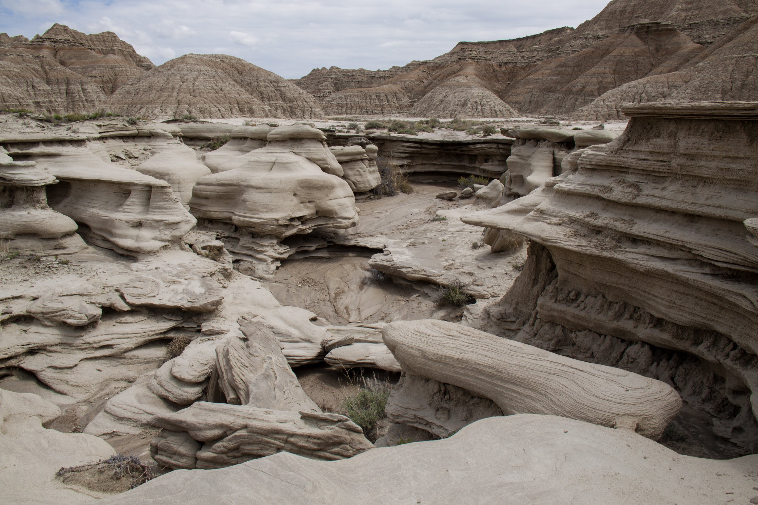
Rock formations in Toadstool Geologic Park, a region of badlands formed on the flank of the Pine Ridge Escarpment near Crawford, NE, the far Northwest of state
In Northwest Nebraska, there are unusual rock formations that resemble toadstools. Many call Toadstool Geologic Park the moonscape of the badlands and it is comparable to surrealist landscapes.
The unique formations are layers of sandstone and faster eroding clay that have left large caps on top of pillars that eventually collapse. The park features fossil tracks preserved in stone from 30 million years ago. Some of the animals include ancient dogs, horses, and rhinoceroses along with other extinct animals.
There are informative signs and an interpretive brochure for self-guided tours that detail the geology and the history of the region. The one-mile dirt hiking loop trailhead begins at the picnic area and contains access to the three-mile Bison Trail. The longer trek takes the hiker to the Hudson-Meng Bonebed which is the largest Bison bone bed in North America.
Toadstool Geologic Park requires self-registration and is $3 for day use and $15 to dry camp. The park provides six first-come, first-serve campsites, two vault toilets, and no running water.
To reach the Park, you will need to drive a 17-mile gravel road. Our next destination, Fort Robinson, is less than an hour away.
Fort Robinson State Park

Historic Fort Robinson State Park, Northwestern Nebraska, west of Crawford, the site in 1879 where the death of famed Sioux Chief Crazy Horse occurred
Fort Robinson State Park is a National Historic Landmark and was one of the largest frontier U.S. Army Forts in the late 19th century during the Indian Wars and remained in use until after WWII. Today, it is a public recreation park with 22,000 acres of preservation areas with several historic structures. The state park features lodging from single rooms to buildings that can accommodate up to 60 people as well as different camping options. There are two museums, the Trailside Museum and the Fort Robinson Museum. Additionally, the state park features a Buffalo Herd, Stage Couch rides, trout fishing, hiking, biking, golfing, a restaurant and store, and a playhouse in the summer among many other activities. Fort Robinson has become a vacation and family reunion getaway.
Fort Robinson began as one of three locations for the Red Cloud Agency, a precursor to modern Indian Reservations. Troops arrived in 1874, establishing the location as Camp Robinson, named after a Lieutenant killed a month before by Native Americans while escorting a woodcutting party near Fort Laramie. The Red Cloud Agency left in 1877 while Fort Robinson developed into a strategic post against the Northern Cheyenne and Lakota tribes. Once the railroad arrived, Fort Robinson surpassed Fort Laramie as the most important military base of operations in the region.
The Lakota Leader, Tasunke Witko, best known as Crazy Horse, and famous for his role in the resonating defeat of Custer and the Seventh Cavalry at the Battle of Little Bighorn, spent his remaining days at Fort Robinson, a year after the famous battle. His tribe surrendered to General Crook at the Red Cloud Agency after suffering from cold and starvation. Crazy Horse was fatally wounded by a bayonet in 1877 at the age of 35, following a fight with Soldiers who were trying to imprison him into a cell. There is a historical marker in front of the reconstructed 1874 Guard House where Crazy Horse was killed.
Another significant event is the Fort Robinson massacre which occurred in the winter of 1878-1879. 350 Northern Cheyenne led by Little Wolf and Dull Knife escaped from the Darlington Agency in the Southern Cheyenne Reservation, part of present-day Oklahoma. The Native Americans wanted to return to their ancestral homelands after living in horrible conditions at the agency. The large party of natives spilt into two directions with Little Wolf’s group returning to Montana and Dull Knife’s heading to the Black Hills. Dull Knife’s party was intercepted near Fort Robinson and after a battle, lost in between 32 to 64 people with an additional 23 wounded and the remaining 78 captured.
Others who have stayed at Fort Robinson include African-American Buffalo Soldiers, the K-9 Corp, and German Prisoners of War. The historic fort has a record of significant events, transitions, and importance. A visit to the museum and history center educates the traveler on notable events and military activities at the fort.
Forty-five minutes from Fort Robinson is Agate Fossil Beds National Monument.
Agate Fossil Beds National Monument

Agate Fossil Beds National Monument is located on the Northwestern Panhandle of Nebraska
Agate Fossil Beds National Monument is an internationally recognized fossil site of Miocene-age mammals that was established as a national monument in 1965. Fossils from 18-23 million years ago were found in two hills which would later become known as Carnegie and University Hills.
In 1878, James H. Cook, a local rancher, discovered fossilized bones eroding from the outcrop on what is now known as Carnegie Hill. Paleontologists from around the country to include the Carnegie Museum at Pittsburgh and Yale University spent several summers excavating the sites.
Agate Fossil Beds features prehistoric animal remains that the world hadn’t seen when they were discovered in the late 19th century. Some of the extinct mammal species found at Agate are Menoceras, a pony-sized two horned rhinoceros with three toes; Stenomylus which resembled two feet tall gazelle camels and a bear dog almost as big as a Polar Bear.
Agate Fossil Beds National Monument contains an incredible collection of Native American Artifacts that are worth a visit on its own merits. The pieces are from James Cook, the rancher who found the fossils. In the late 1800s and early 1900s, the Cook family received gifts from Chief Red Cloud of the Lakota Sioux and other Northern Plains Native American tribes. These items were often in exchange for receiving beef and hides which were later tanned and painted.
Some of the gifts were made especially for the Cooks, including buckskin suits for James' sons Harold and John, gloves, and the painted hide showing scenes from the Battle of Little Bighorn, known to the Lakota as the Battle of Greasy Grass.
Agate Fossil Beds National Monument is one of the most remote national parks. There are no food concessions there. Restaurants, grocery stores, and gas stations are 35 to 50 miles away.
There are two relatively short trails at the park. The one-mile Daemonelix Trail is where you can observe daemonelixes which are spiral burrows created from an ancient dry land beaver with powerful claws known as Palaeocastors. The paved 2.8-mile Fossil Hills Trail begins at the visitor's center. This trail loops around University and Carnegie Hills.
From Agate Fossil Beds, we head to the Wildcat Hills where you’ll see Courthouse and Jail Rocks, Chimney Rock, and Scotts Bluff which are all symbols of the great western migration. These buttes rising above the flat landscape were recognizable landmarks for Native Americans, fur traders, and pioneer travelers on the Oregon, California, and Mormon Trails, the Pony Express Trail, and the Sidney Black Hills Stage Road. The first Overland Trail landmark we visit is Scotts Bluff National Monument.
Scotts Bluff National Monument
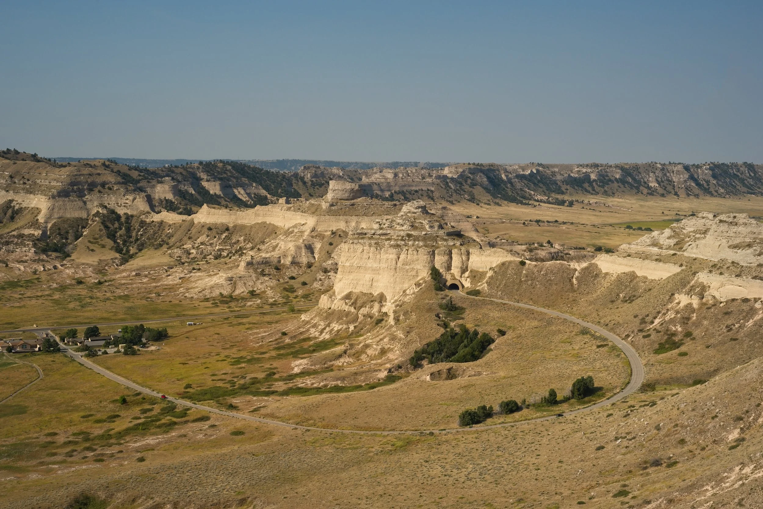
View from top of Scotts Bluff National Monument, Nebraska, overlooking the Oregon Trail museum and road up to the first tunnel
Scotts Bluff is a collection of bluffs that rise 800 feet above the North Platte River and is made up of clay, sandstone, and volcano ash. Scotts Bluff could be seen for days by Plains Natives who were following the buffalo herds during their seasonal migration, along with the approaching emigrants on overland trails that saw it as a significant milestone. Scotts Bluff was named after a clerk from the Rocky Mountain Fur Company, who died near the bluff in 1828.
The monument’s Visitor’s Center consists of interactive learning exhibits and information boards that describe the importance of the area, those who journeyed the land, as well as the difficulties encountered. Near the visitor's center and alongside the easy one-mile Oregon trail pathway, there are replica period wagons and artifacts on display from the mid-1800s and days of oxen and horse drawn travel.
The park has four miles of hiking trails. The moderate Saddle Rock Trail provides a paved footpath that treks to the summit of the monument and features a foot tunnel with a picturesque view from both sides. During the walk, you can follow along to the park’s interesting audio guide, while observing the different types of rocks as you travel up the bluff.
Visitors can drive up to the top of the monument via Scotts Bluff Summit Road or take the park’s Summit Shuttle option. Since the concrete road is the oldest in Nebraska and has three low-clearance tunnels and sharp curves, vehicles longer than 25 feet and/or higher than 11 feet 7 inches and all trailers are prohibited.
Once on the summit, you can view Chimney Rock from the North overlook. Our next destination is Chimney Rock National Historic Site.
Chimney Rock National Historic Site
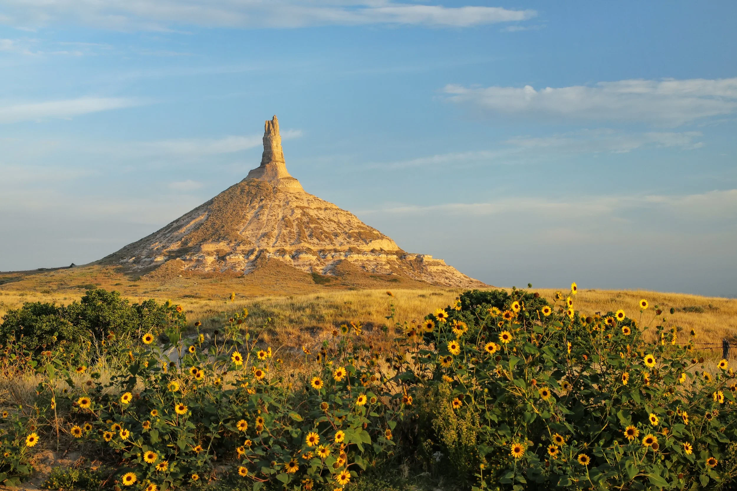
Chimney Rock National Historic Site, Western Nebraska
Chimney Rock is a remnant of the erosion of the bluffs at the edge of the North Platte Valley. The slender spire with a conical base rise nearly 300 feet above the surrounding valley and is visible for many miles.
Chimney Rock is Nebraska’s unofficial state symbol and is commonly featured on license plates, signs, and packaging.
The iconic rock structure is the most noted landmark in overland emigrants' journals. The solitary column could be seen by pioneer travelers for 3 days on their transcontinental journey west. It signaled that they were heading into the second, most difficult, part of their travels and that the mountain passage was near.
Chimney Rock has an outstanding museum that contains informative panels explaining life on the migratory route and an incredible collection of artifacts, artwork, and replica supplies.
If you are interested in hiking up to Chimney Rock, note that the one-mile rugged path will be overgrown so wear pants, and stay alert for possible prairie rattlesnakes. Dogs are not allowed on the trail. The trailhead is not at the museum but a half mile South on 62F and a turn west toward the Chimney Rock Cemetery, where you will find a gravel parking lot. There is a false trailhead on the right, next to a fence, so ensure you stay left towards the rock.
If you are interested, there is a highly rated private campground with great views of Chimney Rock and cattle ranchland, a mile from the museum. It’s called Chimney Rock Pioneer Crossing Campground and provides RV hookups.
Courthouse and Jail Rocks

Cows grazing near Courthouse and Jail Rocks in Nebraska
Our final location in the wildcat hills was the first monumental rock that pioneer travelers encountered on their journey through the plains. Courthouse and Jail Rocks rise 400 feet above the North Platte Valley and are erosional remnants of an ancient plateau composed of clay and sandstone. Emigrants named the rock structures after familiar man-made things and other recorded labels include Castle and Solitary Tower. Courthouse and Jail Rocks are listed in the National Register of Historic Places.
If you are interested in getting closer to the unique buttes, there is a dirt road ½ mile South from the historical marker that will bring you to a parking lot and features a short moderate hike. Dogs on a leash are allowed.
Our next stop is in Alliance for a quirky attraction.
Carhenge

Carhenge - famous car sculpture created by Jim Reinders, a modern replica of England's Stonehenge using old cars., aerial view with a storm in background
Carhenge is a replica of England's Stonehenge, which matches the proportions of the monument. The creator, Jim Reinders, a local Alliance farmer, became intrigued by Stonehenge during his time living in England. Jim realized that the large standing stones of Stonehenge were similar in size to the vintage American automobiles from the 50s and 60s. He knew there were a lot of old abandon vehicles in the area, so he developed the idea of creating his own monument.
During the summer of 1987, Jim and family members built Carhenge in 6 days with a backhoe and tractor. They created the replica as a memorial to Jim’s late father, who was raised on the land. Carhenge contains 38 vintage cars, rescued from nearby farms and dumps.
The carhenge complex is a true open air art museum that contains other unique pieces in addition to the carhenge memorial. Vehicles on site have been spray-painted gray, the windows covered with steel plates, and the wheels welded to the vehicle.
Initially, citizens of Alliance saw Carhenge as a junk yard and disliked the display; however, in August 2013, the city voted to become Carhenge's official owner, giving its blessing to the monument and guaranteeing its preservation. In 2020, Trip Advisor awarded Carhenge, “the Travelers Choice Award” which is only awarded to the top 10% of attractions worldwide! Carhenge is open year-round, from dawn to dusk.
From Alliance, we travel down Highway 2 for an incredible scenic drive through Nebraska’s Sandhills (Nebraska Sand Hills).
Nebraska’s Sandhills

Aerial view of sandy road in Nebraska Sandhills near Seneca, spring scenery with morning light
The Sandhills are 19,000 square miles of sand dunes and make up one-fourth of the Nebraskan landscape. The Sand Dunes are stabilized by grass and reach heights up to 300 feet. The natural wonder was created from deposited sands, from an ancient sea, that were carried to the region by wind. The Nebraska Sand Hills are a National Natural Landmark and is the world’s most intact grasslands.
The area is one of the country’s most isolated and is mostly used for cattle ranching. If you are traveling to the region in early spring, you’ll observe over 500,000 Sandhill Cranes migrate through the area. Bird watchers travel here during this time to enjoy the incredible scene.
The Sandhills can be viewed for 272 miles along Highway 2 and there is an opportunity along the rural route for a small-town tourist stop in Broken Bow.
This road trip plan turns south in the center of Nebraska’s Sandhills, on highway 83. There is a great option for a stop here at the Nebraska National Forest, the world’s largest hand planted forest. The Nebraska National Forest’s Bessey Recreation Complex provides camping, hiking, fishing, among other outdoor activities.

Lookout tower in Nebraska National Forest, aerial view of early fall scenery
A Nebraska Road Trip Travel Guide, Part Two, South Central Nebraska:
This video covers the Golden Spike Tower at Bailey Yard, Buffalo Bill Ranch State Historical Park, the Pony Express Station in Gothenburg and Kearney for the Great Platte River Road Archway Monument and Fort Kearny State Historic Park.
Golden Spike Tower and Visitor Center at Bailey Yard

Fisheye view of Union Pacific's Bailey rail yard from Golden Spike Tower. The world's largest train yard is handling 10,000 cars each day.
After enjoying nature, we visit an iconic railfan mecca, the Golden Spike Tower and Visitor Center at Bailey Yard.
Bailey Yard was named for former Union Pacific president Edd H. Bailey and is the world’s largest railroad classification yard. Bailey Yard covers 2,850 acres, reaching a total length of eight miles and is in the middle of the east-west and north-south corridors.
The yard is the busiest freight rail line in America. Each day, Bailey Yard manages 10,000 railroad cars. Of those, 3,000 are sorted to ensure cargo reaches its destination. Bailey Yard is open 24 hours a day, seven days a week.
The Bailey Yard’s Golden Spike Tower is open to the public and includes a visitor’s center. The tower provides information, exhibits, and panoramic views of the massive rail yard on its’ 7th and 8th floors. The tower’s 7th-floor is an open-air observation deck, where you can hear the hussle and bustle of the yard. The 8th floor is fully enclosed and offers great views of Bailey Yard and the surrounding area. After operating for 105 years, passenger rail services were discontinued in 1971.
Our next stop is the Buffalo Bill Ranch State Historical Park which Buffalo Bill called Scout’s Rest Ranch and the locals at the time called, “The Mansion on the Prairie”.
Buffalo Bill Ranch State Historical Park

Farm and house of the famous Buffalo Bill near North Platte in Nebraska
Scout’s Rest Ranch belonged to famed American West scout and Wild West Show producer William F. “Buffalo Bill” Cody. The ranch was Buffalo Bill’s home from 1886 to 1913. He raised cattle and purebred stallions on his 4,000 acres of land.
The State Historical Park recaptures the life and career of the famed Pony Express rider, Army scout, buffalo hunter, and international showman. The house and barn have been restored and a wealth of Cody memorabilia has been acquired and placed on display. The mansion is open to the public for self-guided tours from late spring until early fall.
There is camping and picnicking facilities available at the adjoining Buffalo Bill Ranch State Recreation Area. They have many pricing options for camping from $10 to $35 a night. Other activities available include hiking, fishing, and an archery range.
While at the Buffalo Bill Ranch, check out the nearby rodeo grounds called Nebraskaland Days. The facility offers rodeos and concerts.
Pony Express Station in Gothenburg (Sam Machette Station Museum)
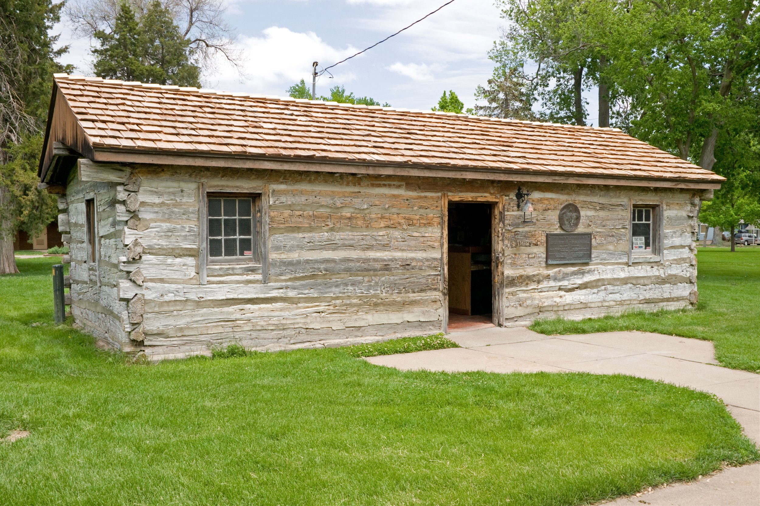
Original Pony Express Station in 1860-61 in Gothenburg, Nebraska, erected in 1854 on the Oregon Trail as a fur trading post and ranch house. Moved to current location in 1931.
Along our drive east, we stop to stretch in Gothenburg and to step back in time at an original pony express station.
Gothenburg is home to the Sam Machette Station Museum, a former Pony Express Station. The cabin is one of few original stations left in existence. The structure was donated to the city of Gothenburg in 1931 and then moved to its current location in Ehmen Park. The Pony Express Station is a quick stop off interstate-80 and is open during the year from April 3rd through October 24th. Admission is free.
The Pony Express was a mail service done via Horseback Relay that delivered messages, newspapers, and mail. The government also used the Pony Express to get messages out to the military. The Pony Express ran between Missouri to California, taking ten days or less. At the time, a stagecoach took twice as long at a minimum and a ship would take six to eight weeks. The Pony Express only operated for 19 months, from April 3, 1860, to October 24, 1861, due to the invention of the Transcontinental Telegraph.
Our first attraction in Kearney is the Great Platte River Road Archway Monument.
Great Platte River Road Archway Monument (The Archway)

Kearney, Nebraska: Great Platte River Road Archway Monument (also known as The Archway or Kearney Archway) over I-80. Exterior view with bison or American Buffalo sculpture and wildflowers.
The imposing brown arch covered bridge over highway 80 is the Great Platte River Road Archway Monument which is part of a fun family-friendly history museum called the Archway.
The museum features realistic, life-size, multimedia exhibits that illustrate the journey along the pioneer trails, stagecoach routes, transcontinental railroad, and the modern Lincoln Highway. Visitors follow along using a handheld audio guide.
The museum complex also includes access to a hiking and biking trail. Four miles south on the trail leads to Fort Kearny, our next destination.
Fort Kearny (Fort Kearney)

Fort Kearny log fence at sunrise
Fort Kearny was constructed in 1848 and was the first fort built to protect wagon trains on the Oregon and California Trails. During its peak period, 800 wagons and 10,000 oxen would pass through in a single day.
Fort Kearny served as a home station for Pony Express riders and Pawnee scouts. It was an important stage station for builders of the Union Pacific Railroad and Mount Rushmore National Memorial.
In 1871, Fort Kearny was discontinued as a military post, the buildings torn down, and the land opened for homesteading. The structures at the historic outpost have been reconstructed. Visitors can tour the stockade, parade grounds, powder magazine, along with the blacksmith and carpenter shop.
Other Nearby Attractions not featured in this Nebraska Travel Guide but worth looking into are:
The Cowboy Trail in Northern Nebraska, which is one of the largest Rails-to-Trails projects in the United States
In the Northeast: Ashfall Fossil Beds in Royal; Elkhorn Valley Museum in Norfolk which includes exhibits on hometown hero, Johnny Carson, and the Calamus Outfitters for Sandhill Safari Jeep Tours in Burwell
In the Northwest: Museum of the Fur Trade in Chadron, Bowring Ranch State Historical Park, as well as Valentine for Snake River Falls, Niobrara National Scenic River, Fort Niobrara National Wildlife Refuge, and the Valentine National Wildlife Refuge
In the Southwest: McCook for the Museum of the High Plains and Frank Lloyd Wright’s Sutton House
In the Southeast: Homestead National Historical Park in Beatrice and Stuhr Museum of the Prairie Pioneer in Grand Island
In Omaha: Henry Doorly Zoo and Aquarium, the Old Market, Joslyn Art Museum, Durham Museum, and Lewis and Clark National Historic Trail Headquarters and Visitor Center
In Iowa, across the Missouri River from Omaha, is the Union Pacific Railroad Museum in Council Bluffs
A road trip across Western and Central Nebraska is relaxing and quite enjoyable. The beautiful rolling sand hills, historic landmarks, amazing geological formations, and interesting attractions make the drive worth the effort. There are many activities for travelers with different interests and should never be a drive through state.
Please consider supporting this work by subscribing to the “Travel Guides from Kris” YouTube Channel.
Happy Planning!
