

Definitive South Dakota and Nebraska Road Trip Guide: Black Hills, Badlands, and Sandhills
If you love underrated road trips, this one is for you. We are driving through South Dakota's pine-covered Black Hills, into the surreal, eroded geological formations of the Badlands, and down into the Nebraska high plains to experience the treeless, rolling, grass-stabilized landscape of the largest sand dune formation in the Western Hemisphere. It is breathtaking, untamed, and right inside the American heartland.
Whether you are actively planning a road trip or simply dreaming of one, this blog will take you on a journey through the open roads of South Dakota and Nebraska.
Join my family and me as we explore must-see attractions, hidden gems, and the rich history and local character of this remarkable stretch of the Great Plains of the Midwest.
Along the way, I will go beyond the scenery to share the stories, history, and people behind these places, because that is what makes a road trip truly unforgettable.
This guide also highlights lessons learned and extra sightseeing options to help you plan your own adventure.
As a family rooted in the busy rhythms of city life in Ohio, we find that heading out West always brings a deep sense of peace and grounding, and I hope this blog gives you a taste of that same feeling.
This guide details our 14-day journey, highlighting scenic stops, family-friendly experiences, and ideas on where to spend your time.
Our trip ran from the evening of July 25 through the morning of August 9, though a few stops along the way were revisits from previous fall and winter trips.
If crowds are a concern, traveling during the shoulder season in the Black Hills is worth considering. Quieter roads and fewer visitors make for a more relaxed experience, though be aware that several roads typically close starting in mid-December.
My channel’s most successful YouTube video so far is my South Dakota Road Trip Plan from four years ago. My original South Dakota and Nebraska videos and blogs are on TravelGuidesfromKris.com under the “Great Plains” tab. These blogs go into greater detail on many of the destinations covered in this guide.
I planned this family road trip itinerary in Excel, and this is the same timeline we followed along the way. We didn't make it to every place listed; some destinations swapped days, and you'll notice that I've included some scattered notes in my spreadsheet. I'll walk you through the plan as we go and include other notable attractions to consider for your own trip.
To me, the highlights of this trip are driving the scenic highways around Custer State Park, watching the sunrise and sunset over the Badlands, and taking a long drive through the wide, rolling hills of the Nebraska Sandhills.
Our eventful road trip kicked off at the Missouri River Confluence, where western Iowa, northeast Nebraska, and southeast South Dakota meet, and then carried us deep into the historically rich region of South Dakota.
Along the way, we stopped at the unique Corn Palace and the powerful Dignity of Earth and Sky sculpture, then visited the classic Wall Drug for a quick meal and browsing before settling into a peaceful boondocking spot near the Badlands. Heading west, we caught the vibrant pre-rally energy in Sturgis and explored the historic streets of Deadwood. We then spent four nights in Custer State Park, taking time to truly absorb the landscape, hiking to Roughlock Falls, driving the dramatic Needles Highway, fishing, and visiting Mount Rushmore, Wind Cave, and Jewel Cave.
Beyond the Black Hills, we explored the stark beauty of the Badlands in both South Dakota and Nebraska. After visiting Badlands National Park and the Mammoth Site in Hot Springs, we continued to see the unusual formations of Toadstool Geological Park and the historic grounds of nearby Fort Robinson before driving further into the heart of Nebraska. A quick stop at Alliance brought us to Carhenge, a modern Stonehenge-like art installation made entirely of cars. From there, much of the day was spent crossing the vast, sparsely populated Sandhills before wrapping up the journey with a memorable visit to the Omaha Zoo.
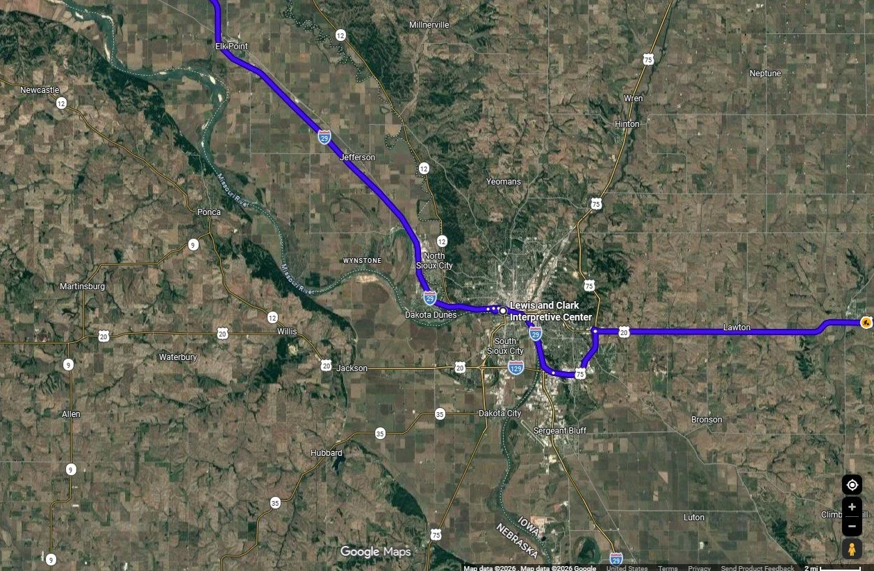
First stop on the road trip, mapped in Google Maps
Sioux City
My family's Road Trip began in Sioux City, at the three-state corner of Iowa, South Dakota, and Nebraska.
Our first destination was the Lewis and Clark Interpretive Center, which offers a valuable opportunity to learn about the expedition's journey and its interactions with Native American tribes. This informative, quick-but-well-done museum is located on a scenic bluff overlooking the Missouri River and an adjacent marina.
Outside the Center, visitors can view engaging sculptures by Wyoming artist Mike Flanagan, including several life-sized bronze animals installed on the grounds of the Interpretive Center and the adjacent Betty Strong Encounter Center, which explores the cultural encounters between Native Americans and European Americans along the river. The 14-foot bronze Spirit of Discovery statue, created by Colorado artist Pat Kennedy and installed in 2002, depicts Meriwether Lewis and William Clark with their Newfoundland dog, Seaman. Note that the Lewis and Clark Interpretive Center is closed on Mondays.
Next door, the Sergeant Floyd River Museum & Welcome Center operates out of a dry-docked 1932 towboat. It spans three levels, featuring exhibits on Missouri River history, Lewis and Clark expedition artifacts, and a large collection of steamboat models. Visitors can explore a pilot house and local history displays throughout the vessel. The Welcome Center also serves as a tri-state Iowa Welcome Center and is open daily, making it a useful stop for travelers seeking information on Nebraska and South Dakota.
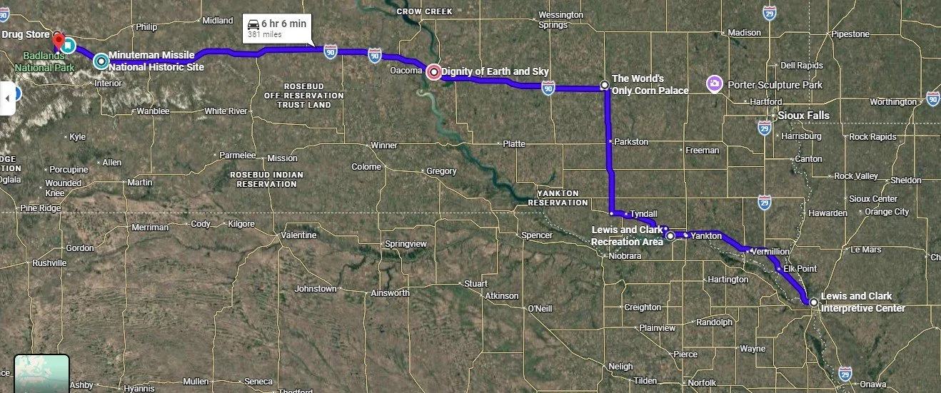
First leg of the road trip, mapped in Google Maps
Lewis and Clark Recreation State Park
Next was our overnight location. For us, a stop at the Lewis and Clark Recreation State Park was dependent on when we departed for our road trip and how long it took to reach South Dakota from Ohio.
I called the morning of our stop to secure the campsite. We didn’t take advantage of the park and lake, but I hope to make it back to go boating, hiking, and for my family to fish.
The Lewis and Clark Recreation State Park sits on the 25-mile-long, man-made reservoir on the Missouri River known as Lewis and Clark Lake. Gavins Point Dam created the lake to manage flooding, aid navigation, and generate hydropower.
While we were at the State Park, we bought an annual state park entrance license for $60; instead of paying $10 per day, we were in a South Dakota State Park during our trip.
Our next campsite was in the Badlands. We made four stops along the way.
World's Only Corn Palace
The first was the World's Only Corn Palace, opened in 1892, where interesting, massive corn art is displayed along the building's façade and around the top of the gymnasium. The exterior corn murals are replaced annually and made from over 275,000 ears of corn, grains, and grasses. The interior of the building showcases pictures of designs from previous years. During the peak tourist season, the gymnasium floor has a large gift shop.
Dignity of Earth and Sky and the Lewis and Clark Welcome Center
Our second stop brought us to the blufftop site overlooking the Missouri River, home to the Dignity of Earth and Sky and the Lewis and Clark Welcome Center. The striking 50-foot stainless-steel statue honors the strength and resilience of the Lakota and Dakota people and glows beautifully when illuminated at night. The sculpture depicts a Native American woman in Plains-style dress with her arms outstretched, holding a star quilt. This textile tradition is deeply rooted in Lakota and Dakota culture. There, star quilts are given as gifts to mark significant life events, serving as symbols of honor and blessing. Dignity of Earth and Sky is a powerful and memorable sculpture created by Dale Claude Lamphere and funded by a Rapid City couple in 2014. The accompanying Lewis and Clark welcome center includes exhibits tracing the Lewis and Clark Expedition’s journey, and there is no shortage of travel brochures to grab for this trip or the next.
1880 Town
About 80 minutes along Interstate 90, you’ll notice the roadside attraction called the 1880 town. The town has over thirty authentic buildings from 1880 to 1920, among other things, to explore.
Minuteman Missile National Historic Site
Along the drive, we made a quick stop at the Minuteman Missile National Historic Site, right off Interstate 90. We arrived when the rangers were locking the gate since it had just closed at 4 pm. Unfortunately, with no information boards or exhibits outside, there wasn’t much to do but peek through the fence and imagine what we missed. The site is designed to educate visitors about the Cold War, the nuclear arms race, and the role of nuclear deterrence that defined an era.
Wall Drug Store
Our next stop, the Wall Drug store, was more fun than I had expected. Spread across multiple buildings, it offers everything from Western-themed apparel to books, plus a cafeteria-style restaurant. The highlight for my girls, though, was the abundance of amusing photo opportunities. Ready to escape the crowded energy of Wall Drug, we headed out in search of the quiet solitude of our campsite for the night.
Badlands Boondock Campspot
One of my favorite evenings of the trip was spent at the Badlands Boondock Campspot, also known as the Nomad View dispersed camping area, located in the Buffalo Gap National Grassland just outside the northern boundary of Badlands National Park near Wall. We arrived late, so there weren’t many sites left to choose from, but we still secured an incredible view of the Badlands wall. After capping off the day with a peaceful sunset and stargazing under the vast night sky, we woke to watch the morning light illuminate the jagged terrain.
We didn’t stay long since the National Park was planned for later in the trip. I chose to visit destinations closer to Sturgis before the motorcycle rally started four days later. After admiring a gorgeous sunrise over the Badlands, we broke camp early to cover some ground, officially kicking off the Black Hills portion of our trip.
Full Day of Driving Around on Day Three, mapped in Google Maps
The Black Hills
The Black Hills are known as Paha Sapa to the Lakota Sioux, meaning “hills that are black,” a fitting name for these pine-covered peaks that rise dark and dramatic against the horizon.
The Black Hills rise in a gentle, dome-shaped swell, formed around 70–50 million years ago during the Laramide Orogeny, when ancient layers of rock were pushed up through Earth’s crust. Today, that dramatic past sets the stage for some of the region’s most scenic drives, many of which wind through and around Custer State Park, where granite spires, forested hills, and sweeping vistas unfold around every curve.
Sturgis
Our first stop in the Black Hills was Sturgis, the “City of Riders,” to get a feel for the town as it prepared for the world's largest motorcycle rally, held in early August. It is in Sturgis where we stopped at the grocery store to pick up some food for the campsite, including steak and local beer.
The Sturgis historic town center is a walkable, vibrant downtown hub with local dining, shopping, and a unique atmosphere that celebrates biker culture. Four days before the motorcycle rally, the area was lined with vendors, food stands, and stages.
I hope to return one day to check out the Sturgis Motorcycle Museum & Hall of Fame and peruse the shops selling denim, leather, and patriotic pride.
Bear Butte
I also want to check out the nearby Bear Butte State Park, which is 14 minutes from Sturgis. Bear Butte takes its name from Mato Paha, or “Bear Mountain” in Lakota, and Noahvose, meaning “Giving Hill” or “Where the Cheyenne Are Taught,” in Cheyenne.
Bear Butte is a sacred landmark where Lakota perform vision quests for spiritual guidance, and the Cheyenne believe the prophet Sweet Medicine received sacred knowledge, foundational laws, and the Four Sacred Arrows from the Creator at Bear Butte.
Bear Butte is a classic example of a laccolith, which is an intrusive igneous rock formation. It formed when molten magma forced its way between horizontal layers of sedimentary rock, causing them to bulge upward into a dome. Because this magma solidified underground rather than erupting, erosion later exposed it to a prominent, dome-shaped hill.
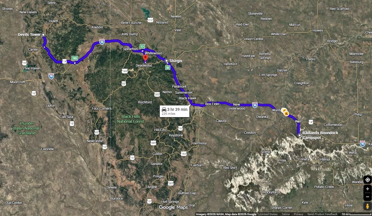
Devil’s Tower
Deadwood was the main destination on day three, but we made time to stop at Devil's Tower, the 867-foot monolith rising out of Wyoming's prairie that our daughters had to see in person. Known as Mato Tipila in Lakota, meaning "Bear Lodge," it was designated the nation's first national monument by Theodore Roosevelt in 1906. It’s as striking in person as it is in photos.
We took in the view from the picnic area before deciding to get a closer look, but the line for the main visitor center’s parking lot barely budged. Summer parking here is tight, so we decided to move on since my husband and I had been there before, and the girls didn’t mind. We turned around and watched the prairie dogs before leaving the park for the Tatanka: Story of the Bison Museum.
The detour to Devil’s Tower cost us a few extra hours, but we also made a stop at the Northeast Wyoming Visitor Center off I-90. Our daughters made the most of the photo opportunities scattered throughout the exhibits, while I stocked up on travel information.
Quick side note: if you’re looking for deeper history and more detailed info on many of the stops described, please check out my South Dakota and Nebraska videos and blogs at Travel Guides from Kris.
Tatanka Story of Bison
Just off Highway 85 on the way into Deadwood, the Tatanka: Story of the Bison is an easy, worthwhile stop, even if the ticket price feels a bit steep. The site serves as a memorial and education center dedicated to the bison. It is anchored by dramatic, larger-than-life bronze sculptures behind the building, created by Peggy Detmers, titled the Lakota Bison Jump. The three-dimensional artwork accompanying the museum illustrates a buffalo hunt featuring 14 bison pursued by three Lakota riders.
The interpretive center was inspired by Kevin Costner, who wanted to share the impact the Northern Plains had on him during the filming of Dances with Wolves. Inside, you’ll also find original pieces from the film on display.
The cultural center’s focus is on the history and near extinction of the bison, as well as their significance to Native American culture and daily life.
It’s a powerful reminder of how quickly things change. In the early 1800s, roughly 60 million bison roamed the plains. By 1889, fewer than 1,000 remained due to overhunting. Today, conservation efforts have helped their numbers rebound to around 500,000, with several Black Hills parks maintaining thriving herds.
Days of ‘76 and the Adams Museum
Just minutes down the hill at the junction of Highways 85 and 14A, the Days of '76 Museum drops you straight into 1876, the rowdy, gold-rush year that put Deadwood on the map. It was here that 25,000 fortune seekers flooded the gulch, and where Jack McCall shot Wild Bill Hickok during a poker game in one of the West’s most infamous moments. Today, the museum brings that frontier energy to life while celebrating the annual Days of ’76, an elite rodeo and festival held each July. Inside, exhibits preserve the spirit of the Black Hills with artifacts ranging from horse-drawn wagons and stagecoaches to classic rodeo memorabilia.
We skipped the museum this time, but plan to visit on our next trip. Instead, we headed into Deadwood to explore the Adams Memorial Museum.
The center preserves and displays exhibits that bring the story of the Black Hills to life, from Native American culture and gold rush days to the larger-than-life legends of the Wild West. Even better, the museum offers a kid-friendly scavenger hunt that turns wandering through the exhibits into a fun, hands-on adventure.
The Company Deadwood History Inc operates the Days of 76’ Museum and Adams Museum, as well as the Brothel Deadwood and the Historic Adams House.
Deadwood
After the Adams Museum, we wandered into the Deadwood Historic District to take in the energy of Main Street. It is a breathtaking step into a bygone era, a place where the legends of Deadwood Dick, Wild Bill, and Calamity Jane are woven into the very timber and storied streets of this untamed frontier. Today, beautifully restored buildings, many revived by casino revenue, blend Old West grit with a lively, modern edge, where more than 20 casinos now light up the historic strip.
At Saloon No. 10, we caught a reenactment of Jack McCall’s capture, part of a summer series staged three times daily, Monday through Saturday. The bar leans into its legend as the site where Hickok was shot mid–poker hand in 1876, adding an extra layer of drama to the experience.
The action spills onto the street with the Deadwood Alive Main Street Shootout, where actors recreate some of the town’s most infamous gunfights. Among them is the brutal 1877 clash between Tom Smith and David Lunt, a story made even more unbelievable by the fact that Lunt survived for 67 days after being shot before finally succumbing. You can find the full list of showtimes and details on their official social media or at DeadwoodAlive.com.
Before leaving Deadwood on Day Four, we visited Mount Moriah Cemetery to see the graves of iconic Wild West legends and enjoyed panoramic views of the town below.
We didn't make it to the Broken Boot Gold Mine or the Adams House on this trip. Both are on our radar for next time, as each offers a deeper look into Deadwood's rich and storied past.
For a fun keepsake, Woody's Wild West Portrait Emporium is within walking distance of the historic corridor. As the country's longest-running old-time photo studio, it features more than 25 authentic historical sets and over 1,000 costume combinations for all ages.
If you are interested in car shows, check out Kool Deadwood Nites, held each year in late August. The event includes live music and activities and serves as a major fundraiser supporting the preservation of historic Deadwood.
From Deadwood, we traveled to the DC Booth National Fish Hatchery, founded in 1889. This site helped establish trout populations throughout the Black Hills, restoring fish stocks depleted by overfishing and industrialization. Today, it’s a free, scenic stop where you can feed thousands of trout, explore the Victorian Booth House, and see a restored fisheries rail car.
While our daughters napped, my husband and I traded off on the short, sub-mile loop up to the Mount Roosevelt Friendship Tower. Built in 1919 by Deadwood sheriff Seth Bullock as a tribute to his friend Theodore Roosevelt, the stone tower feels quietly tucked into the hills. The climb is easy, but the payoff is big, wide-open views stretching out to Bear Butte on the horizon.
Just down Roosevelt Road, you’ll also find free dispersed camping scattered throughout Black Hills National Forest, a simple, scenic spot if you’re looking to stay close to it all. Remember that roads in the National Forests are rough and can be challenging, especially after rain, so you should have a four-wheel-drive vehicle if you choose to explore them.
On the drive from Deadwood to Spearfish Canyon, the road winds through Lead, a mile-high town shaped by gold and grit. Here, the Sanford Lab Homestake Visitor Center opens to a sweeping view of the massive Open Cut, its walls plunging 1,250 feet into the earth, while exhibits trace the quiet shift from gold mining to underground science.
Just a minute down the road, the Black Hills Mining Museum takes you deeper into the past, with a simulated mine tour and stories from the 1876 gold rush that still echoes through these hills.
Now we head deeper into the Black Hills, where the scenery turns raw and intimate. Spearfish Canyon slips into steep limestone walls, and Custer State Park drops you right into the rugged heart of it all.
Spearfish Canyon
After leaving Lead, the route joins the Spearfish Canyon Scenic Byway (U.S. Highway 14A), a roughly 20-mile stretch connecting Cheyenne Crossing, a historic landmark and popular stop, to Spearfish. The road winds into a deep, narrow gorge carved by Spearfish Creek, tracing the path of an old railroad line that was washed out and abandoned after the floods of 1933. Spearfish Canyon feels like a truly meeting place of landscapes, where plants from the Rocky Mountains, eastern woodlands, northern forests, and the Great Plains come together in an outstanding, majestic corridor.
Along the way, we took two short, accessible nature walks. The Roughlock Falls Trail, often accessed near the Spearfish Canyon Lodge, features a multi-tiered waterfall cascading down a 50-foot limestone ledge. Nearby, the trail to the serene Spearfish Falls, an approximately 47-foot waterfall, starts behind the Latchstring Restaurant and descends to the canyon floor.
The Spearfish Canyon Scenic Byway features breathtaking stops, including the 60-foot Bridal Veil Falls, which peak in spring but offer a peaceful, dramatic view from an observation deck across from an off-the-highway parking lot.
If you’re looking to escape the crowds, Eleventh Hour Gulch is tucked deep in Spearfish Canyon, perfect for a little adventure off the beaten path! This narrow, shaded route stays cool year-round and climbs quickly through dramatic rock walls, with just enough challenge to keep it interesting. It’s especially striking in winter, when the waterfalls freeze into quiet, sculpted ice, turning the whole place into something a little surreal.
Next, we headed to Custer State Park for a three-night camp at Sylvan Lake, followed by a night at the Custer State Park Game Lodge campground.
Custer State Park is one of those rare places that feels every bit as grand as a national park. Spanning 71,000 acres, it's one of the largest state parks in the country, with room to roam, scenery that never lets up, and better access to scenic drives like Iron Mountain Road, Needles Highway, and Wildlife Loop Road.
The park is home to a herd of more than 1,400 free-roaming bison, and it’s not uncommon to spot pronghorn, elk, bighorn sheep, prairie dogs, and even the friendly, curious burros, so keep your camera close.
For a little surprise, keep an eye on the cliffs. Mountain goats, native to Canada, made their home here after an escape in 1924 from the Custer State Park Zoo. Today, you’ll often find them perched high above the trails near Black Elk Peak and the Cathedral Spires, moving across the granite as if it were second nature.
The landscape here feels bold and cinematic at every turn. Cruise the Needles Highway as it winds between soaring pinnacles, pause along the calm, reflective shores of Sylvan Lake, and soak in the rolling, pine-covered hills that give the park its rugged character.
To truly immerse yourself in this landscape, I highly recommend hitting the trails. Wandering through the ponderosa-dotted hills and open prairies is the best way to spot local wildlife and get up close with the park’s unique geology.
And if you would rather experience it on horseback, Blue Bell Stables offers guided trail rides and pony rides from mid-May through September, with one-hour rides through the scenic French Creek Nature Area and two-hour backcountry rides for those wanting a longer adventure. Professional wranglers lead each group, so no prior experience is needed, and "Lil' Buckaroo" pony rides are available for children under 7. Call ahead to secure a reservation, as walk-ins are not always guaranteed.
Custer State Park is named for Lt. Col. George Armstrong Custer, who led a military and scientific expedition into the Black Hills in 1874. After gold was discovered, settlers flooded the region, violating an 1868 treaty that had reserved 60 million acres for the Sioux. In 1876, Crazy Horse and his warriors defeated Custer’s troops at the Battle of the Little Bighorn, one of the era’s defining conflicts. Today, the same rugged landscape that shaped this history invites visitors to explore at a slower pace.
Peter Norbeck Scenic Byway
Beyond the Spearfish Canyon Scenic Byway, three additional scenic drives showcase the region's dramatic beauty. The Needles Highway (SD 87), Iron Mountain Road (US 16A), and the Wildlife Loop Road in Custer State Park make up the 70-mile Peter Norbeck National Scenic Byway.
The Peter Norbeck Scenic Byway is a can’t-miss loop, an almost roller-coaster ride through towering pines, granite spires, and sweeping mountain vistas that unfold around every curve. Much of what makes this region so special can be traced back to Peter Norbeck himself, a former governor and U.S. senator who helped shape the Black Hills as we know them today, from championing Mount Rushmore to preserving Custer State Park and even scouting routes like Iron Mountain Road on horseback.
The oval-shaped byway connects the area's most iconic destinations and is best driven unhurriedly to take in every twist, turn, and tunnel along the way. If you are traveling in an RV, pay close attention to clearances throughout the route. Needles Highway and Iron Mountain Road have strict vehicle height and width limits due to their narrow tunnels, generally requiring vehicles to be under 11 feet high and 8'4" wide at the tightest points. Large RVs, long trailers, and wide buses are generally advised against these routes, though small camper vans may pass with extreme caution.
If you are traveling in an RV or prefer to sit back and take it all in, Custer State Park Resort offers dedicated Scenic Byway Tours covering both the Needles Highway and Iron Mountain Road, a great way to experience these narrow, tunnel-filled routes without getting behind the wheel yourself. Also, keep in mind that portions of the byway, including the Needles Highway and Iron Mountain Road, typically close from mid-October through early April due to snow, so be sure to plan your visit accordingly.
More to come:
Please return in June to read about the rest of the trip. The route is far from over. Scenic Byways, Mount Rushmore, the caves, more of the Black Hills, and the Badlands are all in the second half.
And if you want to go deeper, I'm putting together a South Dakota Travel Handbook, available on Amazon this August. It'll be packed with more stops, more background, and more ideas for the road. And it's the first in a series I'm building on the Great Plains of the Midwest.
Thank you for reading. Happy planning!